Mons geodata
Mons (Occitanie) is a populated place; located in France in Europe/Paris (GMT+2) time zone. With population of 1,490 people, there are 6229 cities with bigger population in this country. Compared to other cities in France, 86.1% of cities are located further ↑North; 69.5% of cities are located further ←West and 68.6% of cities have lower elevation than Mons. Note1
Administrative division(s):
- Level 1: Occitanie
- Level 2: Gard
- Level 3: Arrondissement d’Alès
- Level 4: Mons


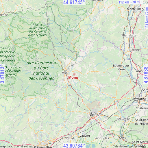
Mons GPS coordinates[2]
44° 6' 53.28" North, 4° 10' 23.7" East
| Map corner | latitude | longitude |
|---|---|---|
| Upper-left | 44.61745°, | 3.47013° |
| Center: | 44.1148°, | 4.17325° |
| Lower-right: | 43.60784°, | 4.87638° |
| Map W x H: | 112.3×112.3 km | = 69.8×69.8mi |
| max Lat: | 51.07786° ⇑86.1% North |
| Mons: | 44.1148° |
| min Lat: | ⇓13.9% South 41.3874° |
| min Long | Mons | max Long |
| -5.08615° | 4.17325° | 9.52242° |
| W 69.5%⇐ | ⇒30.5% E |
Elevation
Elevation of Mons is 212 m = 696 ft, and this is 18.3 m = 60 ft above average elevation for this country.
| Max E: |
2333 m = 7654 ft | 31.4% |
| Mons | 212 m 696 ft | |
| Avg. | 193.7 m = 635 ft | |
Min E: |
-1 m = -3 ft | 68.6% |
See also: France elevation on elevation.city.
Geographical zone
Mons is located in North temperate zone (between Tropic of Cancer and the Arctic Circle). Distance of this Northern Tropic circle is 2299.2 km =1428.7 mi to South.| Distance of | km | miles | from Mons |
|---|---|---|---|
| North Pole | 5102 | 3170.2 | to North |
| Arctic Circle | 2496.1 | 1551 | to North |
| Tropic Cancer | 2299.2 | 1428.7 | to South |
| Equator | 4905.1 | 3047.9 | to South |


Nearby cities:
15 places around Mons: (largest is in red/bold)
• Alès
7.5 km =4.7 mi,  278°
278°
• Brouzet-lès-Alès
6.2 km =3.9 mi,  67°
67°
• Cendras
9.4 km =5.8 mi,  294°
294°
• Deaux
5.7 km =3.5 mi,  199°
199°
• Méjannes-lès-Alès
2.3 km =1.4 mi,  218°
218°
• Ners
9.8 km =6.1 mi,  185°
185°
• Rousson
8.8 km =5.5 mi,  346°
346°
• Saint-Christol-lès-Alès
8.6 km =5.3 mi,  245°
245°
• Saint-Hilaire-de-Brethmas
5.5 km =3.4 mi,  225°
225°
• Saint-Julien-de-Cassagnas
10.7 km =6.6 mi,  10°
10°
• Saint-Julien-les-Rosiers
8.4 km =5.2 mi,  321°
321°
• Saint-Martin-de-Valgalgues
8.9 km =5.5 mi,  306°
306°
• Saint-Privat-des-Vieux
4.8 km =3 mi, 313°
• Salindres
6.4 km =4 mi, 350°
• Vézénobres
7.6 km =4.7 mi, 201°
Sources, notices
• [Note1] Compared only with cities in France existing in our database
• [Src1] Map data: © OpenStreetMap contributors (CC-BY-SA)
• [Src2] Other city data from geonames.org with taken over terms of usage.
• [Src3] Geographical zone / Annual Mean Temperature by Robert A. Rohde @ Wikipedia
