Saint-Victor-de-Malcap geodata
Saint-Victor-de-Malcap (Occitanie) is a populated place; located in France in Europe/Paris (GMT+2) time zone. With population of 594 people, there are 13430 cities with bigger population in this country. Compared to other cities in France, 85.1% of cities are located further ↑North; 69.9% of cities are located further ←West and 58% of cities have lower elevation than Saint-Victor-de-Malcap. Note1
Administrative division(s):
- Level 1: Occitanie
- Level 2: Gard
- Level 3: Arrondissement d’Alès
- Level 4: Saint-Victor-de-Malcap
Current local time in Saint-Victor-de-Malcap:
05:25 PM, SaturdayDifference from your time zone: hours


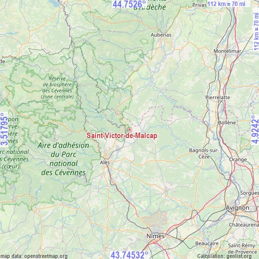
Saint-Victor-de-Malcap GPS coordinates[2]
44° 15' 4.032" North, 4° 13' 15.852" East
| Map corner | latitude | longitude |
|---|---|---|
| Upper-left | 44.7526°, | 3.51795° |
| Center: | 44.25112°, | 4.22107° |
| Lower-right: | 43.74532°, | 4.9242° |
| Map W x H: | 112×112 km | = 69.6×69.6mi |
| max Lat: | 51.07786° ⇑85.1% North |
| Saint-Victor-de-Malcap: | 44.25112° |
| min Lat: | ⇓14.9% South 41.3874° |
| min Long | Saint-Victor-de | max Long |
| -5.08615° | 4.22107° | 9.52242° |
| W 69.9%⇐ | ⇒30.1% E |
Elevation
Elevation of Saint-Victor-de-Malcap is 161 m = 528 ft, and this is 32.7 m = 107 ft below average elevation for this country.
| Max E: |
2333 m = 7654 ft | 42% |
| Avg. | 193.7 m = 635 ft | |
| Saint-Victor-de-Malcap | 161 m = 528 ft | |
Min E: |
-1 m = -3 ft | 58% |
See also: France elevation on elevation.city.
Geographical zone
Saint-Victor-de-Malcap is located in North temperate zone (between Tropic of Cancer and the Arctic Circle). Distance of this Northern Tropic circle is 2314.3 km =1438 mi to South.| Distance of | km | miles | from Saint-Victor-de-Malcap |
|---|---|---|---|
| North Pole | 5086.8 | 3160.8 | to North |
| Arctic Circle | 2480.9 | 1541.6 | to North |
| Tropic Cancer | 2314.3 | 1438 | to South |
| Equator | 4920.3 | 3057.3 | to South |


Nearby cities:
15 places around Saint-Victor-de-Malcap: (largest is in red/bold)
• Allègre-les-Fumades
6 km =3.7 mi,  161°
161°
• Gagnières
9.6 km =6 mi,  309°
309°
• Les Mages
4.8 km =3 mi,  238°
238°
• Meyrannes
4.8 km =3 mi,  297°
297°
• Molières-sur-Cèze
5.1 km =3.2 mi,  281°
281°
• Robiac-Rochessadoule
7.2 km =4.5 mi, 283°
• Rousson
8.8 km =5.5 mi,  221°
221°
• Saint-Ambroix
2 km =1.2 mi, 295°
• Saint-André-de-Cruzières
7.1 km =4.4 mi,  357°
357°
• Saint-Florent-sur-Auzonnet
8.7 km =5.4 mi,  262°
262°
• Saint-Jean-de-Maruéjols-et-Avéjan
5.9 km =3.7 mi,  84°
84°
• Saint-Jean-de-Valériscle
6.4 km =4 mi,  248°
248°
• Saint-Julien-de-Cassagnas
4.9 km =3 mi,  200°
200°
• Saint-Sauveur-de-Cruzières
6 km =3.7 mi,  25°
25°
• Salindres
10.1 km =6.3 mi,  208°
208°
Sources, notices
• [Note1] Compared only with cities in France existing in our database
• [Src1] Map data: © OpenStreetMap contributors (CC-BY-SA)
• [Src2] Other city data from geonames.org with taken over terms of usage.
• [Src3] Geographical zone / Annual Mean Temperature by Robert A. Rohde @ Wikipedia
