Allan geodata
Allan (Auvergne-Rhône-Alpes) is a populated place; located in France in Europe/Paris (GMT+2) time zone. With population of 1,517 people, there are 6130 cities with bigger population in this country. Compared to other cities in France, 83.6% of cities are located further ↑North; 74.9% of cities are located further ←West and 64.6% of cities have lower elevation than Allan. Note1
Administrative division(s):
- Level 1: Auvergne-Rhône-Alpes
- Level 2: Département de la Drôme
- Level 3: Arrondissement de Nyons
- Level 4: Allan


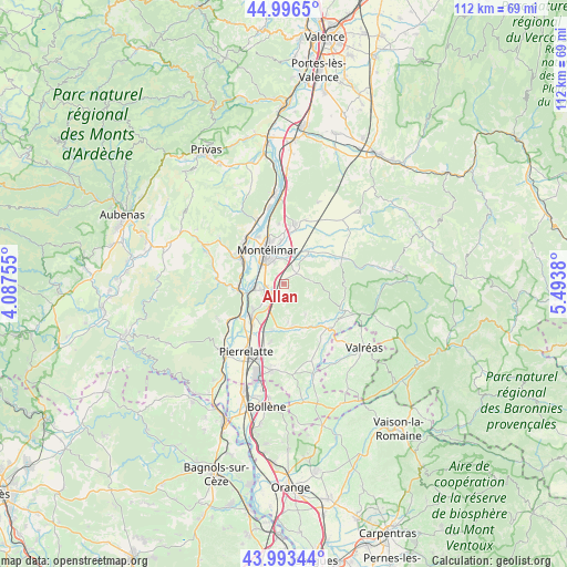
Allan GPS coordinates[2]
44° 29' 49.668" North, 4° 47' 26.448" East
| Map corner | latitude | longitude |
|---|---|---|
| Upper-left | 44.9965°, | 4.08755° |
| Center: | 44.49713°, | 4.79068° |
| Lower-right: | 43.99344°, | 5.4938° |
| Map W x H: | 111.5×111.5 km | = 69.3×69.3mi |
| max Lat: | 51.07786° ⇑83.6% North |
| Allan: | 44.49713° |
| min Lat: | ⇓16.4% South 41.3874° |
| min Long | Allan | max Long |
| -5.08615° | 4.79068° | 9.52242° |
| W 74.9%⇐ | ⇒25.1% E |
Elevation
Elevation of Allan is 192 m = 630 ft, and this is 1.7 m = 6 ft below average elevation for this country.
| Max E: |
2333 m = 7654 ft | 35.4% |
| Avg. | 193.7 m = 635 ft | |
| Allan | 192 m = 630 ft | |
Min E: |
-1 m = -3 ft | 64.6% |
See also: France elevation on elevation.city.
Geographical zone
Allan is located in North temperate zone (between Tropic of Cancer and the Arctic Circle). Distance of this Northern Tropic circle is 2341.7 km =1455.1 mi to South.| Distance of | km | miles | from Allan |
|---|---|---|---|
| North Pole | 5059.4 | 3143.8 | to North |
| Arctic Circle | 2453.6 | 1524.6 | to North |
| Tropic Cancer | 2341.7 | 1455.1 | to South |
| Equator | 4947.6 | 3074.3 | to South |


Nearby cities:
15 places around Allan: (largest is in red/bold)
• Ancône
10.6 km =6.6 mi,  331°
331°
• Châteauneuf-du-Rhône
5.9 km =3.7 mi,  261°
261°
• Donzère
8.8 km =5.5 mi,  226°
226°
• Espeluche
3.3 km =2.1 mi,  47°
47°
• La Bâtie-Rolland
8.6 km =5.3 mi,  43°
43°
• La Garde-Adhémar
11.4 km =7.1 mi,  193°
193°
• Le Teil
10.1 km =6.3 mi,  301°
301°
• Les Granges-Gontardes
9.2 km =5.7 mi, 193°
• Malataverne
3.2 km =2 mi,  246°
246°
• Montboucher-sur-Jabron
6 km =3.7 mi,  8°
8°
• Montélimar
7 km =4.3 mi,  335°
335°
• Saint-Marcel-lès-Sauzet
11.2 km =7 mi, 5°
• Savasse
12 km =7.5 mi,  354°
354°
• Valaurie
8.3 km =5.2 mi,  168°
168°
• Viviers
8.2 km =5.1 mi, 258°
Sources, notices
• [Note1] Compared only with cities in France existing in our database
• [Src1] Map data: © OpenStreetMap contributors (CC-BY-SA)
• [Src2] Other city data from geonames.org with taken over terms of usage.
• [Src3] Geographical zone / Annual Mean Temperature by Robert A. Rohde @ Wikipedia
