Viviers geodata
Viviers (Auvergne-Rhône-Alpes) is a populated place; located in France in Europe/Paris (GMT+2) time zone. With population of 3,616 people, there are 2700 cities with bigger population in this country. Compared to other cities in France, 83.7% of cities are located further ↑North; 73.6% of cities are located further ←West and 77.8% of cities have higher elevation than Viviers. Note1
Administrative division(s):
- Level 1: Auvergne-Rhône-Alpes
- Level 2: Département de l'Ardèche
- Level 3: Arrondissement de Privas
- Level 4: Viviers


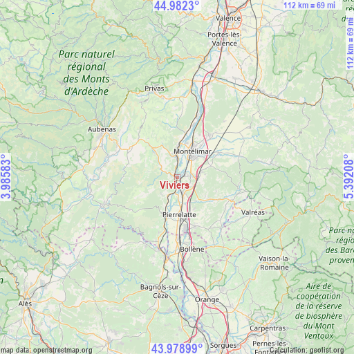
Viviers GPS coordinates[2]
44° 28' 58.08" North, 4° 41' 20.22" East
| Map corner | latitude | longitude |
|---|---|---|
| Upper-left | 44.9823°, | 3.98583° |
| Center: | 44.4828°, | 4.68895° |
| Lower-right: | 43.97899°, | 5.39208° |
| Map W x H: | 111.6×111.6 km | = 69.3×69.3mi |
| max Lat: | 51.07786° ⇑83.7% North |
| Viviers: | 44.4828° |
| min Lat: | ⇓16.3% South 41.3874° |
| min Long | Viviers | max Long |
| -5.08615° | 4.68895° | 9.52242° |
| W 73.6%⇐ | ⇒26.4% E |
Elevation
Elevation of Viviers is 60 m = 197 ft, and this is 133.7 m = 439 ft below average elevation for this country.
| Max E: |
2333 m = 7654 ft | 77.8% |
| Avg. | 193.7 m = 635 ft | |
| Viviers | 60 m = 197 ft | |
Min E: |
-1 m = -3 ft | 22.2% |
See also: France elevation on elevation.city.
Geographical zone
Viviers is located in North temperate zone (between Tropic of Cancer and the Arctic Circle). Distance of this Northern Tropic circle is 2340.1 km =1454.1 mi to South.| Distance of | km | miles | from Viviers |
|---|---|---|---|
| North Pole | 5061 | 3144.8 | to North |
| Arctic Circle | 2455.2 | 1525.6 | to North |
| Tropic Cancer | 2340.1 | 1454.1 | to South |
| Equator | 4946 | 3073.3 | to South |


Nearby cities:
15 places around Viviers: (largest is in red/bold)
• Alba-la-Romaine
10.8 km =6.7 mi,  318°
318°
• Allan
8.2 km =5.1 mi,  78°
78°
• Ancône
11.3 km =7 mi,  15°
15°
• Châteauneuf-du-Rhône
2.3 km =1.4 mi,  72°
72°
• Donzère
4.8 km =3 mi,  158°
158°
• Espeluche
11.2 km =7 mi, 70°
• La Garde-Adhémar
11 km =6.8 mi,  150°
150°
• Le Teil
7 km =4.3 mi,  355°
355°
• Les Granges-Gontardes
9.5 km =5.9 mi,  140°
140°
• Malataverne
5.1 km =3.2 mi,  86°
86°
• Montboucher-sur-Jabron
11.7 km =7.3 mi,  49°
49°
• Montélimar
9.5 km =5.9 mi,  33°
33°
• Pierrelatte
12 km =7.5 mi,  174°
174°
• Rochemaure
11.7 km =7.3 mi,  5°
5°
• Valaurie
11.7 km =7.3 mi,  124°
124°
Sources, notices
• [Note1] Compared only with cities in France existing in our database
• [Src1] Map data: © OpenStreetMap contributors (CC-BY-SA)
• [Src2] Other city data from geonames.org with taken over terms of usage.
• [Src3] Geographical zone / Annual Mean Temperature by Robert A. Rohde @ Wikipedia
