La Garde-Adhémar geodata
La Garde-Adhémar (Auvergne-Rhône-Alpes) is a populated place; located in France in Europe/Paris (GMT+2) time zone. With population of 1,169 people, there are 7716 cities with bigger population in this country. Compared to other cities in France, 84.3% of cities are located further ↑North; 74.4% of cities are located further ←West and 60% of cities have lower elevation than La Garde-Adhémar. Note1
Administrative division(s):
- Level 1: Auvergne-Rhône-Alpes
- Level 2: Département de la Drôme
- Level 3: Arrondissement de Nyons
- Level 4: La Garde-Adhémar


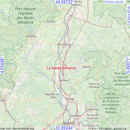
La Garde-Adhémar GPS coordinates[2]
44° 23' 49.164" North, 4° 45' 27.324" East
| Map corner | latitude | longitude |
|---|---|---|
| Upper-left | 44.89722°, | 4.05446° |
| Center: | 44.39699°, | 4.75759° |
| Lower-right: | 43.89244°, | 5.46071° |
| Map W x H: | 111.7×111.7 km | = 69.4×69.4mi |
| max Lat: | 51.07786° ⇑84.3% North |
| La Garde-Adhémar: | 44.39699° |
| min Lat: | ⇓15.7% South 41.3874° |
| min Long | La Garde-Adhém | max Long |
| -5.08615° | 4.75759° | 9.52242° |
| W 74.4%⇐ | ⇒25.6% E |
Elevation
Elevation of La Garde-Adhémar is 170 m = 558 ft, and this is 23.7 m = 78 ft below average elevation for this country.
| Max E: |
2333 m = 7654 ft | 40% |
| Avg. | 193.7 m = 635 ft | |
| La Garde-Adhémar | 170 m = 558 ft | |
Min E: |
-1 m = -3 ft | 60% |
See also: France elevation on elevation.city.
Geographical zone
La Garde-Adhémar is located in North temperate zone (between Tropic of Cancer and the Arctic Circle). Distance of this Northern Tropic circle is 2330.6 km =1448.2 mi to South.| Distance of | km | miles | from La Garde-Adhémar |
|---|---|---|---|
| North Pole | 5070.6 | 3150.7 | to North |
| Arctic Circle | 2464.7 | 1531.5 | to North |
| Tropic Cancer | 2330.6 | 1448.2 | to South |
| Equator | 4936.5 | 3067.4 | to South |


Nearby cities:
15 places around La Garde-Adhémar: (largest is in red/bold)
• Allan
11.4 km =7.1 mi,  13°
13°
• Bourg-Saint-Andéol
9.4 km =5.8 mi,  253°
253°
• Chamaret
9.8 km =6.1 mi,  89°
89°
• Châteauneuf-du-Rhône
10.7 km =6.6 mi,  342°
342°
• Donzère
6.2 km =3.9 mi,  324°
324°
• La Baume-de-Transit
10.9 km =6.8 mi,  127°
127°
• Lapalud
11.3 km =7 mi,  208°
208°
• Les Granges-Gontardes
2.3 km =1.4 mi, 13°
• Malataverne
9.8 km =6.1 mi,  357°
357°
• Montségur-sur-Lauzon
8.7 km =5.4 mi,  117°
117°
• Pierrelatte
4.9 km =3 mi,  241°
241°
• Saint-Paul-Trois-Châteaux
5.7 km =3.5 mi,  175°
175°
• Saint-Restitut
8.5 km =5.3 mi,  160°
160°
• Valaurie
5.2 km =3.2 mi,  54°
54°
• Viviers
11 km =6.8 mi,  330°
330°
Sources, notices
• [Note1] Compared only with cities in France existing in our database
• [Src1] Map data: © OpenStreetMap contributors (CC-BY-SA)
• [Src2] Other city data from geonames.org with taken over terms of usage.
• [Src3] Geographical zone / Annual Mean Temperature by Robert A. Rohde @ Wikipedia
