Alixan geodata
Alixan (Auvergne-Rhône-Alpes) is a populated place; located in France in Europe/Paris (GMT+2) time zone. With population of 2,229 people, there are 4310 cities with bigger population in this country. Compared to other cities in France, 79.8% of cities are located further ↑North; 77.9% of cities are located further ←West and 65.4% of cities have lower elevation than Alixan. Note1
Administrative division(s):
- Level 1: Auvergne-Rhône-Alpes
- Level 2: Département de la Drôme
- Level 3: Arrondissement de Valence
- Level 4: Alixan


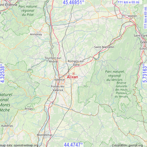
Alixan GPS coordinates[2]
44° 58' 27.336" North, 5° 1' 42.6" East
| Map corner | latitude | longitude |
|---|---|---|
| Upper-left | 45.46951°, | 4.32538° |
| Center: | 44.97426°, | 5.0285° |
| Lower-right: | 44.4747°, | 5.73163° |
| Map W x H: | 110.6×110.6 km | = 68.7×68.7mi |
| max Lat: | 51.07786° ⇑79.8% North |
| Alixan: | 44.97426° |
| min Lat: | ⇓20.2% South 41.3874° |
| min Long | Alixan | max Long |
| -5.08615° | 5.0285° | 9.52242° |
| W 77.9%⇐ | ⇒22.1% E |
Elevation
Elevation of Alixan is 196 m = 643 ft, and this is 2.3 m = 8 ft above average elevation for this country.
| Max E: |
2333 m = 7654 ft | 34.6% |
| Alixan | 196 m 643 ft | |
| Avg. | 193.7 m = 635 ft | |
Min E: |
-1 m = -3 ft | 65.4% |
See also: France elevation on elevation.city.
Geographical zone
Alixan is located in North temperate zone (between Tropic of Cancer and the Arctic Circle). Distance of this Northern Tropic circle is 2394.7 km =1488 mi to South.| Distance of | km | miles | from Alixan |
|---|---|---|---|
| North Pole | 5006.4 | 3110.8 | to North |
| Arctic Circle | 2400.5 | 1491.6 | to North |
| Tropic Cancer | 2394.7 | 1488 | to South |
| Equator | 5000.7 | 3107.3 | to South |


Nearby cities:
15 places around Alixan: (largest is in red/bold)
• Barbières
8.9 km =5.5 mi,  101°
101°
• Beaumont-Monteux
10 km =6.2 mi,  300°
300°
• Bourg-de-Péage
6.6 km =4.1 mi,  14°
14°
• Bésayes
3.9 km =2.4 mi, 103°
• Chabeuil
8.5 km =5.3 mi,  187°
187°
• Charpey
6.5 km =4 mi,  128°
128°
• Chatuzange-le-Goubet
5.9 km =3.7 mi,  56°
56°
• Châteaudouble
9.8 km =6.1 mi,  148°
148°
• Châteauneuf-sur-Isère
8.8 km =5.5 mi, 302°
• Marches
6.3 km =3.9 mi,  88°
88°
• Montélier
4.4 km =2.7 mi,  177°
177°
• Peyrus
9.1 km =5.7 mi,  139°
139°
• Rochefort-Samson
9.6 km =6 mi, 92°
• Romans-sur-Isère
8.9 km =5.5 mi,  19°
19°
• Saint-Marcel-lès-Valence
5.9 km =3.7 mi,  266°
266°
Sources, notices
• [Note1] Compared only with cities in France existing in our database
• [Src1] Map data: © OpenStreetMap contributors (CC-BY-SA)
• [Src2] Other city data from geonames.org with taken over terms of usage.
• [Src3] Geographical zone / Annual Mean Temperature by Robert A. Rohde @ Wikipedia
