Saint-Marcel-lès-Valence geodata
Saint-Marcel-lès-Valence (Auvergne-Rhône-Alpes) is a populated place; located in France in Europe/Paris (GMT+2) time zone. With population of 4,420 people, there are 2235 cities with bigger population in this country. Compared to other cities in France, 79.8% of cities are located further ↑North; 77.2% of cities are located further ←West and 58.4% of cities have lower elevation than Saint-Marcel-lès-Valence. Note1
Administrative division(s):
- Level 1: Auvergne-Rhône-Alpes
- Level 2: Département de la Drôme
- Level 3: Arrondissement de Valence
- Level 4: Saint-Marcel-lès-Valence
Current local time in Saint-Marcel-lès-Valence:
05:56 AM, WednesdayDifference from your time zone: hours


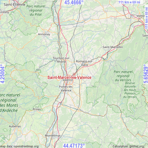
Saint-Marcel-lès-Valence GPS coordinates[2]
44° 58' 16.752" North, 4° 57' 11.376" East
| Map corner | latitude | longitude |
|---|---|---|
| Upper-left | 45.4666°, | 4.25004° |
| Center: | 44.97132°, | 4.95316° |
| Lower-right: | 44.47173°, | 5.65629° |
| Map W x H: | 110.6×110.6 km | = 68.7×68.7mi |
| max Lat: | 51.07786° ⇑79.8% North |
| Saint-Marcel-lès-Valence: | 44.97132° |
| min Lat: | ⇓20.2% South 41.3874° |
| min Long | Saint-Marcel-l� | max Long |
| -5.08615° | 4.95316° | 9.52242° |
| W 77.2%⇐ | ⇒22.8% E |
Elevation
Elevation of Saint-Marcel-lès-Valence is 163 m = 535 ft, and this is 30.7 m = 101 ft below average elevation for this country.
| Max E: |
2333 m = 7654 ft | 41.6% |
| Avg. | 193.7 m = 635 ft | |
| Saint-Marcel-lès-Valence | 163 m = 535 ft | |
Min E: |
-1 m = -3 ft | 58.4% |
See also: France elevation on elevation.city.
Geographical zone
Saint-Marcel-lès-Valence is located in North temperate zone (between Tropic of Cancer and the Arctic Circle). Distance of this Northern Tropic circle is 2394.4 km =1487.8 mi to South.| Distance of | km | miles | from Saint-Marcel-lès-Valence |
|---|---|---|---|
| North Pole | 5006.7 | 3111 | to North |
| Arctic Circle | 2400.8 | 1491.8 | to North |
| Tropic Cancer | 2394.4 | 1487.8 | to South |
| Equator | 5000.3 | 3107 | to South |


Nearby cities:
15 places around Saint-Marcel-lès-Valence: (largest is in red/bold)
• Alixan
5.9 km =3.7 mi,  86°
86°
• Beaumont-Monteux
6 km =3.7 mi,  333°
333°
• Bourg-de-Péage
10.1 km =6.3 mi,  48°
48°
• Bourg-lès-Valence
5.3 km =3.3 mi,  239°
239°
• Bésayes
9.7 km =6 mi, 93°
• Chabeuil
9.4 km =5.8 mi,  149°
149°
• Chanos-Curson
10.2 km =6.3 mi,  346°
346°
• Châteauneuf-sur-Isère
5.3 km =3.3 mi,  342°
342°
• Cornas
8.3 km =5.2 mi,  264°
264°
• Guilherand-Granges
7.6 km =4.7 mi, 235°
• La Roche-de-Glun
9.7 km =6 mi,  298°
298°
• Malissard
8 km =5 mi,  179°
179°
• Montélier
7.4 km =4.6 mi,  123°
123°
• Saint-Péray
8.9 km =5.5 mi,  253°
253°
• Valence
6.1 km =3.8 mi,  214°
214°
Sources, notices
• [Note1] Compared only with cities in France existing in our database
• [Src1] Map data: © OpenStreetMap contributors (CC-BY-SA)
• [Src2] Other city data from geonames.org with taken over terms of usage.
• [Src3] Geographical zone / Annual Mean Temperature by Robert A. Rohde @ Wikipedia
