Aigues-Vives geodata
Aigues-Vives (Occitanie) is a populated place; located in France in Europe/Paris (GMT+2) time zone. With population of 2,525 people, there are 3866 cities with bigger population in this country. Compared to other cities in France, 89.9% of cities are located further ↑North; 69.5% of cities are located further ←West and 81.5% of cities have higher elevation than Aigues-Vives. Note1
Administrative division(s):
- Level 1: Occitanie
- Level 2: Gard
- Level 3: Arrondissement de Nîmes
- Level 4: Aigues-Vives


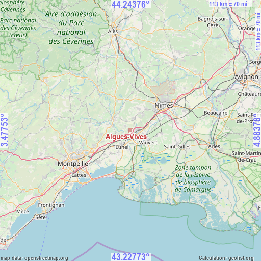
Aigues-Vives GPS coordinates[2]
43° 44' 16.44" North, 4° 10' 50.376" East
| Map corner | latitude | longitude |
|---|---|---|
| Upper-left | 44.24376°, | 3.47753° |
| Center: | 43.7379°, | 4.18066° |
| Lower-right: | 43.22773°, | 4.88378° |
| Map W x H: | 113×113 km | = 70.2×70.2mi |
| max Lat: | 51.07786° ⇑89.9% North |
| Aigues-Vives: | 43.7379° |
| min Lat: | ⇓10.1% South 41.3874° |
| min Long | Aigues-Vives | max Long |
| -5.08615° | 4.18066° | 9.52242° |
| W 69.5%⇐ | ⇒30.5% E |
Elevation
Elevation of Aigues-Vives is 51 m = 167 ft, and this is 142.7 m = 468 ft below average elevation for this country.
| Max E: |
2333 m = 7654 ft | 81.5% |
| Avg. | 193.7 m = 635 ft | |
| Aigues-Vives | 51 m = 167 ft | |
Min E: |
-1 m = -3 ft | 18.5% |
See also: France elevation on elevation.city.
Geographical zone
Aigues-Vives is located in North temperate zone (between Tropic of Cancer and the Arctic Circle). Distance of this Northern Tropic circle is 2257.3 km =1402.6 mi to South.| Distance of | km | miles | from Aigues-Vives |
|---|---|---|---|
| North Pole | 5143.9 | 3196.3 | to North |
| Arctic Circle | 2538 | 1577 | to North |
| Tropic Cancer | 2257.3 | 1402.6 | to South |
| Equator | 4863.2 | 3021.9 | to South |


Nearby cities:
15 places around Aigues-Vives: (largest is in red/bold)
• Aimargues
6.4 km =4 mi,  158°
158°
• Aubais
3.3 km =2.1 mi,  302°
302°
• Boissières
5.8 km =3.6 mi,  45°
45°
• Calvisson
5.6 km =3.5 mi,  12°
12°
• Codognan
3.4 km =2.1 mi,  104°
104°
• Congénies
3.4 km =2.1 mi,  340°
340°
• Gallargues-le-Montueux
2.6 km =1.6 mi,  205°
205°
• Junas
6.1 km =3.8 mi,  307°
307°
• Mus
1.8 km =1.1 mi,  85°
85°
• Saint-Sériès
6.5 km =4 mi,  265°
265°
• Saturargues
5.7 km =3.5 mi,  252°
252°
• Vergèze
3.3 km =2.1 mi,  78°
78°
• Vestric-et-Candiac
6.3 km =3.9 mi, 87°
• Villetelle
3.6 km =2.2 mi,  257°
257°
• Vérargues
6.9 km =4.3 mi, 249°
Sources, notices
• [Note1] Compared only with cities in France existing in our database
• [Src1] Map data: © OpenStreetMap contributors (CC-BY-SA)
• [Src2] Other city data from geonames.org with taken over terms of usage.
• [Src3] Geographical zone / Annual Mean Temperature by Robert A. Rohde @ Wikipedia
