Villetelle geodata
Villetelle (Occitanie) is a populated place; located in France in Europe/Paris (GMT+2) time zone. With population of 1,033 people, there are 8590 cities with bigger population in this country. Compared to other cities in France, 90% of cities are located further ↑North; 69.2% of cities are located further ←West and 92% of cities have higher elevation than Villetelle. Note1
Administrative division(s):
- Level 1: Occitanie
- Level 2: Département de l'Hérault
- Level 3: Arrondissement of Montpellier
- Level 4: Villetelle


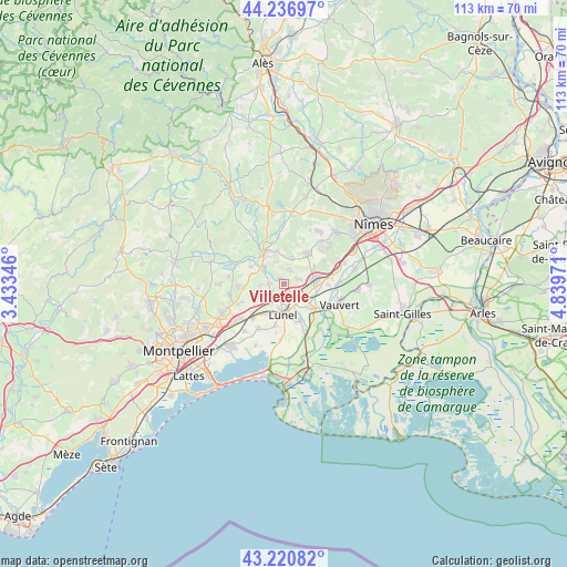
Villetelle GPS coordinates[2]
43° 43' 51.78" North, 4° 8' 11.688" East
| Map corner | latitude | longitude |
|---|---|---|
| Upper-left | 44.23697°, | 3.43346° |
| Center: | 43.73105°, | 4.13658° |
| Lower-right: | 43.22082°, | 4.83971° |
| Map W x H: | 113×113 km | = 70.2×70.2mi |
| max Lat: | 51.07786° ⇑90% North |
| Villetelle: | 43.73105° |
| min Lat: | ⇓10% South 41.3874° |
| min Long | Villetelle | max Long |
| -5.08615° | 4.13658° | 9.52242° |
| W 69.2%⇐ | ⇒30.8% E |
Elevation
Elevation of Villetelle is 25 m = 82 ft, and this is 168.7 m = 553 ft below average elevation for this country.
| Max E: |
2333 m = 7654 ft | 92% |
| Avg. | 193.7 m = 635 ft | |
| Villetelle | 25 m = 82 ft | |
Min E: |
-1 m = -3 ft | 8% |
See also: France elevation on elevation.city.
Geographical zone
Villetelle is located in North temperate zone (between Tropic of Cancer and the Arctic Circle). Distance of this Northern Tropic circle is 2256.5 km =1402.1 mi to South.| Distance of | km | miles | from Villetelle |
|---|---|---|---|
| North Pole | 5144.6 | 3196.7 | to North |
| Arctic Circle | 2538.7 | 1577.5 | to North |
| Tropic Cancer | 2256.5 | 1402.1 | to South |
| Equator | 4862.4 | 3021.4 | to South |


Nearby cities:
15 places around Villetelle: (largest is in red/bold)
• Aigues-Vives
3.6 km =2.2 mi,  77°
77°
• Aubais
2.7 km =1.7 mi,  15°
15°
• Aujargues
6.7 km =4.2 mi,  350°
350°
• Boisseron
5.5 km =3.4 mi,  303°
303°
• Codognan
6.8 km =4.2 mi,  90°
90°
• Congénies
4.6 km =2.9 mi,  31°
31°
• Gallargues-le-Montueux
2.9 km =1.8 mi,  123°
123°
• Junas
4.7 km =2.9 mi,  344°
344°
• Lunel
5.9 km =3.7 mi,  180°
180°
• Lunel-Viel
6.8 km =4.2 mi,  211°
211°
• Mus
5.4 km =3.4 mi, 80°
• Saint-Christol
4.6 km =2.9 mi,  265°
265°
• Saint-Sériès
2.9 km =1.8 mi, 274°
• Saturargues
2.1 km =1.3 mi,  243°
243°
• Vérargues
3.3 km =2.1 mi, 241°
Sources, notices
• [Note1] Compared only with cities in France existing in our database
• [Src1] Map data: © OpenStreetMap contributors (CC-BY-SA)
• [Src2] Other city data from geonames.org with taken over terms of usage.
• [Src3] Geographical zone / Annual Mean Temperature by Robert A. Rohde @ Wikipedia
