Saturargues geodata
Saturargues (Occitanie) is a populated place; located in France in Europe/Paris (GMT+2) time zone. With population of 667 people, there are 12267 cities with bigger population in this country. Compared to other cities in France, 90.1% of cities are located further ↑North; 68.9% of cities are located further ←West and 88.6% of cities have higher elevation than Saturargues. Note1
Administrative division(s):
- Level 1: Occitanie
- Level 2: Département de l'Hérault
- Level 3: Arrondissement of Montpellier
- Level 4: Saturargues


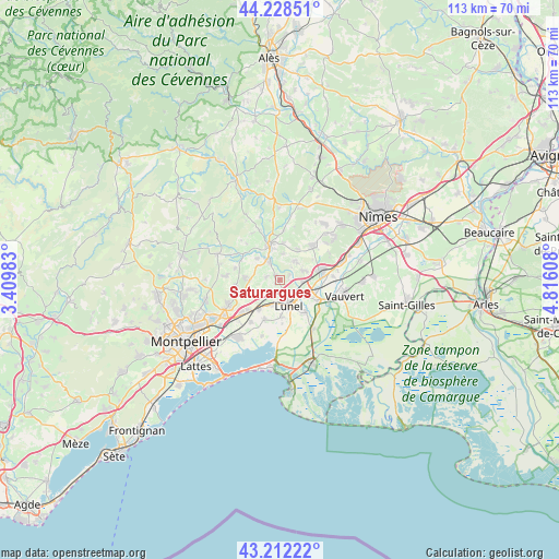
Saturargues GPS coordinates[2]
43° 43' 21.072" North, 4° 6' 46.656" East
| Map corner | latitude | longitude |
|---|---|---|
| Upper-left | 44.22851°, | 3.40983° |
| Center: | 43.72252°, | 4.11296° |
| Lower-right: | 43.21222°, | 4.81608° |
| Map W x H: | 113×113 km | = 70.2×70.2mi |
| max Lat: | 51.07786° ⇑90.1% North |
| Saturargues: | 43.72252° |
| min Lat: | ⇓9.9% South 41.3874° |
| min Long | Saturargues | max Long |
| -5.08615° | 4.11296° | 9.52242° |
| W 68.9%⇐ | ⇒31.1% E |
Elevation
Elevation of Saturargues is 33 m = 108 ft, and this is 160.7 m = 527 ft below average elevation for this country.
| Max E: |
2333 m = 7654 ft | 88.6% |
| Avg. | 193.7 m = 635 ft | |
| Saturargues | 33 m = 108 ft | |
Min E: |
-1 m = -3 ft | 11.4% |
See also: France elevation on elevation.city.
Geographical zone
Saturargues is located in North temperate zone (between Tropic of Cancer and the Arctic Circle). Distance of this Northern Tropic circle is 2255.6 km =1401.6 mi to South.| Distance of | km | miles | from Saturargues |
|---|---|---|---|
| North Pole | 5145.6 | 3197.3 | to North |
| Arctic Circle | 2539.7 | 1578.1 | to North |
| Tropic Cancer | 2255.6 | 1401.6 | to South |
| Equator | 4861.5 | 3020.8 | to South |


Nearby cities:
15 places around Saturargues: (largest is in red/bold)
• Aigues-Vives
5.7 km =3.5 mi,  72°
72°
• Aubais
4.4 km =2.7 mi,  36°
36°
• Boisseron
4.8 km =3 mi,  325°
325°
• Congénies
6.5 km =4 mi, 41°
• Gallargues-le-Montueux
4.4 km =2.7 mi,  98°
98°
• Junas
5.5 km =3.4 mi,  6°
6°
• Lunel
5.3 km =3.3 mi,  159°
159°
• Lunel-Viel
5.1 km =3.2 mi,  198°
198°
• Restinclières
6.3 km =3.9 mi,  270°
270°
• Saint-Christol
2.7 km =1.7 mi,  283°
283°
• Saint-Geniès-des-Mourgues
6.8 km =4.2 mi,  246°
246°
• Saint-Sériès
1.6 km =1 mi,  319°
319°
• Saussines
6.3 km =3.9 mi,  313°
313°
• Villetelle
2.1 km =1.3 mi,  63°
63°
• Vérargues
1.2 km =0.7 mi,  238°
238°
Sources, notices
• [Note1] Compared only with cities in France existing in our database
• [Src1] Map data: © OpenStreetMap contributors (CC-BY-SA)
• [Src2] Other city data from geonames.org with taken over terms of usage.
• [Src3] Geographical zone / Annual Mean Temperature by Robert A. Rohde @ Wikipedia
