Aigueblanche geodata
Aigueblanche (Auvergne-Rhône-Alpes) is a populated place; located in France in Europe/Paris (GMT+2) time zone. With population of 2,919 people, there are 3337 cities with bigger population in this country. Compared to other cities in France, 74.1% of cities are located further ↑North; 91.7% of cities are located further ←West and 94.1% of cities have lower elevation than Aigueblanche. Note1
Administrative division(s):
- Level 1: Auvergne-Rhône-Alpes
- Level 2: Savoie
- Level 3: Albertville
- Level 4: Grand-Aigueblanche


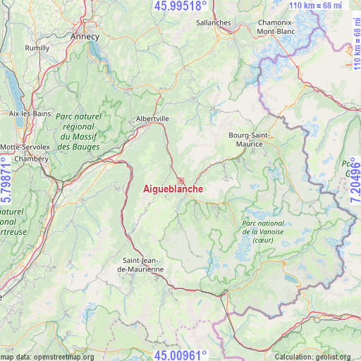
Aigueblanche GPS coordinates[2]
45° 30' 16.38" North, 6° 30' 6.624" East
| Map corner | latitude | longitude |
|---|---|---|
| Upper-left | 45.99518°, | 5.79871° |
| Center: | 45.50455°, | 6.50184° |
| Lower-right: | 45.00961°, | 7.20496° |
| Map W x H: | 109.6×109.6 km | = 68.1×68.1mi |
| max Lat: | 51.07786° ⇑74.1% North |
| Aigueblanche: | 45.50455° |
| min Lat: | ⇓25.9% South 41.3874° |
| min Long | Aigueblanche | max Long |
| -5.08615° | 6.50184° | 9.52242° |
| W 91.7%⇐ | ⇒8.3% E |
Elevation
Elevation of Aigueblanche is 543 m = 1781 ft, and this is 349.3 m = 1146 ft above average elevation for this country.
| Max E: |
2333 m = 7654 ft | 5.9% |
| Aigueblanche | 543 m 1781 ft | |
| Avg. | 193.7 m = 635 ft | |
Min E: |
-1 m = -3 ft | 94.1% |
See also: France elevation on elevation.city.
Geographical zone
Aigueblanche is located in North temperate zone (between Tropic of Cancer and the Arctic Circle). Distance of this North polar circle is 2341.5 km =1454.9 mi to North.| Distance of | km | miles | from Aigueblanche |
|---|---|---|---|
| North Pole | 4947.4 | 3074.2 | to North |
| Arctic Circle | 2341.5 | 1454.9 | to North |
| Tropic Cancer | 2453.7 | 1524.7 | to South |
| Equator | 5059.6 | 3143.9 | to South |


Nearby cities:
15 places around Aigueblanche: (largest is in red/bold)
• Aime
12.9 km =8 mi,  63°
63°
• Bozel
13.4 km =8.3 mi,  120°
120°
• Brides-les-Bains
7.7 km =4.8 mi,  137°
137°
• Cevins
10.3 km =6.4 mi,  339°
339°
• Courchevel
14.4 km =8.9 mi,  133°
133°
• Esserts-Blay
13.2 km =8.2 mi, 337°
• Feissons-sur-Isère
6.6 km =4.1 mi, 338°
• Les Allues
9 km =5.6 mi,  152°
152°
• Moûtiers
3.2 km =2 mi, 133°
• Mâcot-la-Plagne
13.8 km =8.6 mi,  68°
68°
• Méribel
11.1 km =6.9 mi, 153°
• Saint-Bon-Tarentaise
13.1 km =8.1 mi, 126°
• Saint-Martin-de-Belleville
13.7 km =8.5 mi,  178°
178°
• Saint-Paul-sur-Isère
11.5 km =7.1 mi,  334°
334°
• Salins-les-Thermes
4.3 km =2.7 mi, 148°
Sources, notices
• [Note1] Compared only with cities in France existing in our database
• [Src1] Map data: © OpenStreetMap contributors (CC-BY-SA)
• [Src2] Other city data from geonames.org with taken over terms of usage.
• [Src3] Geographical zone / Annual Mean Temperature by Robert A. Rohde @ Wikipedia
