Aime geodata
Aime (Auvergne-Rhône-Alpes) is a populated place; located in France in Europe/Paris (GMT+2) time zone. With population of 3,507 people, there are 2774 cities with bigger population in this country. Compared to other cities in France, 73.3% of cities are located further ↑North; 92.7% of cities are located further ←West and 96.5% of cities have lower elevation than Aime. Note1
Administrative division(s):
- Level 1: Auvergne-Rhône-Alpes
- Level 2: Savoie
- Level 3: Albertville
- Level 4: Aime-la-Plagne


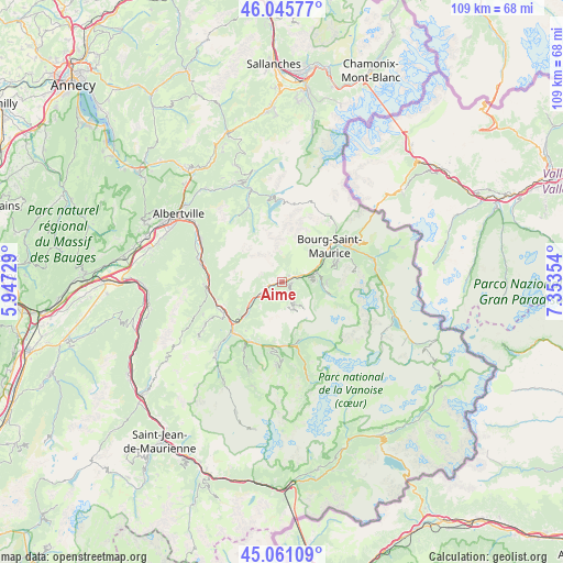
Aime GPS coordinates[2]
45° 33' 20.124" North, 6° 39' 1.512" East
| Map corner | latitude | longitude |
|---|---|---|
| Upper-left | 46.04577°, | 5.94729° |
| Center: | 45.55559°, | 6.65042° |
| Lower-right: | 45.06109°, | 7.35354° |
| Map W x H: | 109.5×109.5 km | = 68×68mi |
| max Lat: | 51.07786° ⇑73.3% North |
| Aime: | 45.55559° |
| min Lat: | ⇓26.7% South 41.3874° |
| min Long | Aime | max Long |
| -5.08615° | 6.65042° | 9.52242° |
| W 92.7%⇐ | ⇒7.3% E |
Elevation
Elevation of Aime is 678 m = 2224 ft, and this is 484.3 m = 1589 ft above average elevation for this country.
| Max E: |
2333 m = 7654 ft | 3.5% |
| Aime | 678 m 2224 ft | |
| Avg. | 193.7 m = 635 ft | |
Min E: |
-1 m = -3 ft | 96.5% |
See also: France elevation on elevation.city.
Geographical zone
Aime is located in North temperate zone (between Tropic of Cancer and the Arctic Circle). Distance of this North polar circle is 2335.9 km =1451.5 mi to North.| Distance of | km | miles | from Aime |
|---|---|---|---|
| North Pole | 4941.8 | 3070.7 | to North |
| Arctic Circle | 2335.9 | 1451.5 | to North |
| Tropic Cancer | 2459.4 | 1528.2 | to South |
| Equator | 5065.3 | 3147.4 | to South |


Nearby cities:
15 places around Aime: (largest is in red/bold)
• Aigueblanche
12.9 km =8 mi,  243°
243°
• Belle-Plagne
6.8 km =4.2 mi,  139°
139°
• Bellentre
5.2 km =3.2 mi,  72°
72°
• Bourg-Saint-Maurice
11.3 km =7 mi,  54°
54°
• Bozel
12.5 km =7.8 mi,  180°
180°
• Brides-les-Bains
13.1 km =8.1 mi,  209°
209°
• Champagny-en-Vanoise
11.7 km =7.3 mi,  163°
163°
• Feissons-sur-Isère
14 km =8.7 mi,  271°
271°
• Landry
7.2 km =4.5 mi, 74°
• Moûtiers
12.2 km =7.6 mi,  229°
229°
• Mâcot-la-Plagne
1.4 km =0.9 mi,  116°
116°
• Peisey-Nancroix
8.2 km =5.1 mi,  97°
97°
• Saint-Bon-Tarentaise
13.6 km =8.5 mi, 184°
• Salins-les-Thermes
13.2 km =8.2 mi, 225°
• Séez
14 km =8.7 mi,  57°
57°
Sources, notices
• [Note1] Compared only with cities in France existing in our database
• [Src1] Map data: © OpenStreetMap contributors (CC-BY-SA)
• [Src2] Other city data from geonames.org with taken over terms of usage.
• [Src3] Geographical zone / Annual Mean Temperature by Robert A. Rohde @ Wikipedia
