Feissons-sur-Isère geodata
Feissons-sur-Isère (Auvergne-Rhône-Alpes) is a populated place; located in France in Europe/Paris (GMT+2) time zone. With population of 547 people, there are 14264 cities with bigger population in this country. Compared to other cities in France, 73.2% of cities are located further ↑North; 91.5% of cities are located further ←West and 89.1% of cities have lower elevation than Feissons-sur-Isère. Note1
Administrative division(s):
- Level 1: Auvergne-Rhône-Alpes
- Level 2: Savoie
- Level 3: Albertville
- Level 4: La Léchère


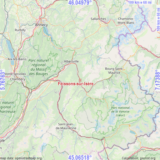
Feissons-sur-Isère GPS coordinates[2]
45° 33' 34.704" North, 6° 28' 14.736" East
| Map corner | latitude | longitude |
|---|---|---|
| Upper-left | 46.04979°, | 5.76763° |
| Center: | 45.55964°, | 6.47076° |
| Lower-right: | 45.06518°, | 7.17388° |
| Map W x H: | 109.5×109.5 km | = 68×68mi |
| max Lat: | 51.07786° ⇑73.2% North |
| Feissons-sur-Isère: | 45.55964° |
| min Lat: | ⇓26.8% South 41.3874° |
| min Long | Feissons-sur-Is | max Long |
| -5.08615° | 6.47076° | 9.52242° |
| W 91.5%⇐ | ⇒8.5% E |
Elevation
Elevation of Feissons-sur-Isère is 409 m = 1342 ft, and this is 215.3 m = 706 ft above average elevation for this country.
| Max E: |
2333 m = 7654 ft | 10.9% |
| Feissons-sur-Isère | 409 m 1342 ft | |
| Avg. | 193.7 m = 635 ft | |
Min E: |
-1 m = -3 ft | 89.1% |
See also: France elevation on elevation.city.
Geographical zone
Feissons-sur-Isère is located in North temperate zone (between Tropic of Cancer and the Arctic Circle). Distance of this North polar circle is 2335.4 km =1451.1 mi to North.| Distance of | km | miles | from Feissons-sur-Isère |
|---|---|---|---|
| North Pole | 4941.3 | 3070.4 | to North |
| Arctic Circle | 2335.4 | 1451.1 | to North |
| Tropic Cancer | 2459.8 | 1528.4 | to South |
| Equator | 5065.8 | 3147.7 | to South |


Nearby cities:
15 places around Feissons-sur-Isère: (largest is in red/bold)
• Aiguebelle
13.1 km =8.1 mi,  262°
262°
• Aigueblanche
6.6 km =4.1 mi,  158°
158°
• Aime
14 km =8.7 mi,  91°
91°
• Brides-les-Bains
14.1 km =8.8 mi,  147°
147°
• Cevins
3.8 km =2.4 mi,  340°
340°
• Esserts-Blay
6.6 km =4.1 mi, 336°
• Grignon
12.5 km =7.8 mi,  324°
324°
• La Bâthie
7.8 km =4.8 mi,  347°
347°
• Moûtiers
9.6 km =6 mi, 150°
• Notre-Dame-des-Millières
12.5 km =7.8 mi,  303°
303°
• Randens
12.6 km =7.8 mi, 263°
• Saint-Paul-sur-Isère
4.9 km =3 mi,  329°
329°
• Sainte-Hélène-sur-Isère
13.2 km =8.2 mi, 297°
• Salins-les-Thermes
10.8 km =6.7 mi, 154°
• Tours-en-Savoie
10.7 km =6.6 mi, 347°
Sources, notices
• [Note1] Compared only with cities in France existing in our database
• [Src1] Map data: © OpenStreetMap contributors (CC-BY-SA)
• [Src2] Other city data from geonames.org with taken over terms of usage.
• [Src3] Geographical zone / Annual Mean Temperature by Robert A. Rohde @ Wikipedia
