Saint-Jérôme geodata
Saint-Jérôme (Provence-Alpes-Côte d'Azur) is a section of populated place; located in France in Europe/Paris (GMT+2) time zone. With population of 10,087 people, there are 943 cities with bigger population in this country. Compared to other cities in France, 95.1% of cities are located further ↑North; 82.1% of cities are located further ←West and 62% of cities have higher elevation than Saint-Jérôme. Note1
Administrative division(s):
- Level 1: Provence-Alpes-Côte d'Azur
- Level 2: Département des Bouches-du-Rhône
- Level 3: Arrondissement de Marseille
- Level 4: Marseille


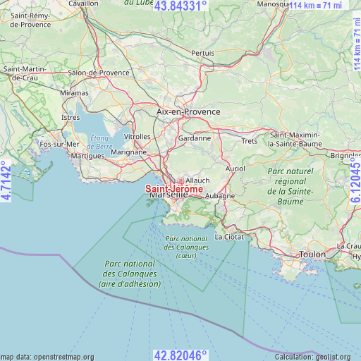
Saint-Jérôme GPS coordinates[2]
43° 20' 2.544" North, 5° 25' 2.388" East
| Map corner | latitude | longitude |
|---|---|---|
| Upper-left | 43.84331°, | 4.7142° |
| Center: | 43.33404°, | 5.41733° |
| Lower-right: | 42.82046°, | 6.12045° |
| Map W x H: | 113.7×113.7 km | = 70.6×70.6mi |
| max Lat: | 51.07786° ⇑95.1% North |
| Saint-Jérôme: | 43.33404° |
| min Lat: | ⇓4.9% South 41.3874° |
| min Long | Saint-Jérôme | max Long |
| -5.08615° | 5.41733° | 9.52242° |
| W 82.1%⇐ | ⇒17.9% E |
Elevation
Elevation of Saint-Jérôme is 97 m = 318 ft, and this is 96.7 m = 317 ft below average elevation for this country.
| Max E: |
2333 m = 7654 ft | 62% |
| Avg. | 193.7 m = 635 ft | |
| Saint-Jérôme | 97 m = 318 ft | |
Min E: |
-1 m = -3 ft | 38% |
See also: France elevation on elevation.city.
Geographical zone
Saint-Jérôme is located in North temperate zone (between Tropic of Cancer and the Arctic Circle). Distance of this Northern Tropic circle is 2212.4 km =1374.7 mi to South.| Distance of | km | miles | from Saint-Jérôme |
|---|---|---|---|
| North Pole | 5188.8 | 3224.2 | to North |
| Arctic Circle | 2582.9 | 1604.9 | to North |
| Tropic Cancer | 2212.4 | 1374.7 | to South |
| Equator | 4818.3 | 2994 | to South |


Nearby cities:
15 places around Saint-Jérôme: (largest is in red/bold)
• Bon-Secours
3.1 km =1.9 mi,  238°
238°
• Chutes-Lavie
3.2 km =2 mi,  214°
214°
• La Croix-Rouge
3 km =1.9 mi,  91°
91°
• La Rose
1.1 km =0.7 mi,  122°
122°
• Le Merlan
0.9 km =0.6 mi,  304°
304°
• Les Arnavaux
3 km =1.9 mi,  272°
272°
• Les Chartreux
2.7 km =1.7 mi,  201°
201°
• Malpassé
1.4 km =0.9 mi,  186°
186°
• Marseille 13
1.9 km =1.2 mi, 202°
• Montolivet
1.9 km =1.2 mi,  165°
165°
• Mouret
3.2 km =2 mi,  18°
18°
• Saint-Barthélémy
1.3 km =0.8 mi,  254°
254°
• Saint-Just
2.1 km =1.3 mi, 206°
• Saint-Mitre
1.4 km =0.9 mi, 17°
• Sainte-Marthe
2.1 km =1.3 mi, 271°
Sources, notices
• [Note1] Compared only with cities in France existing in our database
• [Src1] Map data: © OpenStreetMap contributors (CC-BY-SA)
• [Src2] Other city data from geonames.org with taken over terms of usage.
• [Src3] Geographical zone / Annual Mean Temperature by Robert A. Rohde @ Wikipedia
