Malpassé geodata
Malpassé (Provence-Alpes-Côte d'Azur) is a section of populated place; located in France in Europe/Paris (GMT+2) time zone. With population of 11,148 people, there are 860 cities with bigger population in this country. Compared to other cities in France, 95.2% of cities are located further ↑North; 82.1% of cities are located further ←West and 60.8% of cities have higher elevation than Malpassé. Note1
Administrative division(s):
- Level 1: Provence-Alpes-Côte d'Azur
- Level 2: Département des Bouches-du-Rhône
- Level 3: Arrondissement de Marseille
- Level 4: Marseille


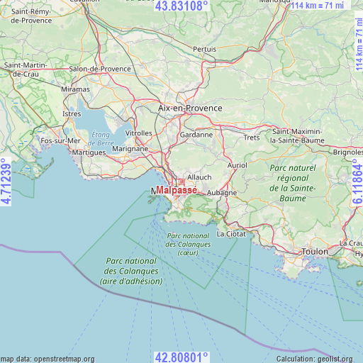
Malpassé GPS coordinates[2]
43° 19' 18.12" North, 5° 24' 55.836" East
| Map corner | latitude | longitude |
|---|---|---|
| Upper-left | 43.83108°, | 4.71239° |
| Center: | 43.3217°, | 5.41551° |
| Lower-right: | 42.80801°, | 6.11864° |
| Map W x H: | 113.8×113.8 km | = 70.7×70.7mi |
| max Lat: | 51.07786° ⇑95.2% North |
| Malpassé: | 43.3217° |
| min Lat: | ⇓4.8% South 41.3874° |
| min Long | Malpassé | max Long |
| -5.08615° | 5.41551° | 9.52242° |
| W 82.1%⇐ | ⇒17.9% E |
Elevation
Elevation of Malpassé is 100 m = 328 ft, and this is 93.7 m = 307 ft below average elevation for this country.
| Max E: |
2333 m = 7654 ft | 60.8% |
| Avg. | 193.7 m = 635 ft | |
| Malpassé | 100 m = 328 ft | |
Min E: |
-1 m = -3 ft | 39.2% |
See also: France elevation on elevation.city.
Geographical zone
Malpassé is located in North temperate zone (between Tropic of Cancer and the Arctic Circle). Distance of this Northern Tropic circle is 2211 km =1373.9 mi to South.| Distance of | km | miles | from Malpassé |
|---|---|---|---|
| North Pole | 5190.1 | 3225 | to North |
| Arctic Circle | 2584.3 | 1605.8 | to North |
| Tropic Cancer | 2211 | 1373.9 | to South |
| Equator | 4816.9 | 2993.1 | to South |


Nearby cities:
15 places around Malpassé: (largest is in red/bold)
• Chutes-Lavie
2.1 km =1.3 mi,  232°
232°
• Cinq Avenues
2.5 km =1.6 mi,  215°
215°
• La Blancarde
2.5 km =1.6 mi,  198°
198°
• La Fourragère
2.4 km =1.5 mi,  147°
147°
• La Rose
1.3 km =0.8 mi,  52°
52°
• Le Merlan
2 km =1.2 mi,  341°
341°
• Les Chartreux
1.5 km =0.9 mi, 216°
• Marseille 04
2.5 km =1.6 mi,  207°
207°
• Marseille 13
0.7 km =0.4 mi,  238°
238°
• Montolivet
0.8 km =0.5 mi,  128°
128°
• Saint-Barnabé
2.4 km =1.5 mi,  177°
177°
• Saint-Barthélémy
1.5 km =0.9 mi,  314°
314°
• Saint-Just
0.9 km =0.6 mi, 236°
• Saint-Jérôme
1.4 km =0.9 mi,  6°
6°
• Sainte-Marthe
2.4 km =1.5 mi, 305°
Sources, notices
• [Note1] Compared only with cities in France existing in our database
• [Src1] Map data: © OpenStreetMap contributors (CC-BY-SA)
• [Src2] Other city data from geonames.org with taken over terms of usage.
• [Src3] Geographical zone / Annual Mean Temperature by Robert A. Rohde @ Wikipedia
