Septèmes-les-Vallons geodata
Septèmes-les-Vallons (Provence-Alpes-Côte d'Azur) is a populated place; located in France in Europe/Paris (GMT+2) time zone. With population of 10,220 people, there are 925 cities with bigger population in this country. Compared to other cities in France, 94.2% of cities are located further ↑North; 81.3% of cities are located further ←West and 65.4% of cities have lower elevation than Septèmes-les-Vallons. Note1
Administrative division(s):
- Level 1: Provence-Alpes-Côte d'Azur
- Level 2: Département des Bouches-du-Rhône
- Level 3: Arrondissement de Marseille
- Level 4: Septèmes-les-Vallons
Current local time in Septèmes-les-Vallons:
06:06 AM, WednesdayDifference from your time zone: hours


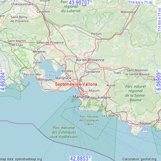
Septèmes-les-Vallons GPS coordinates[2]
43° 23' 54.024" North, 5° 21' 57.456" East
| Map corner | latitude | longitude |
|---|---|---|
| Upper-left | 43.90707°, | 4.66284° |
| Center: | 43.39834°, | 5.36596° |
| Lower-right: | 42.8853°, | 6.06909° |
| Map W x H: | 113.6×113.6 km | = 70.6×70.6mi |
| max Lat: | 51.07786° ⇑94.2% North |
| Septèmes-les-Vallons: | 43.39834° |
| min Lat: | ⇓5.8% South 41.3874° |
| min Long | Septèmes-les-V | max Long |
| -5.08615° | 5.36596° | 9.52242° |
| W 81.3%⇐ | ⇒18.7% E |
Elevation
Elevation of Septèmes-les-Vallons is 196 m = 643 ft, and this is 2.3 m = 8 ft above average elevation for this country.
| Max E: |
2333 m = 7654 ft | 34.6% |
| Septèmes-les-Vallons | 196 m 643 ft | |
| Avg. | 193.7 m = 635 ft | |
Min E: |
-1 m = -3 ft | 65.4% |
See also: France elevation on elevation.city.
Geographical zone
Septèmes-les-Vallons is located in North temperate zone (between Tropic of Cancer and the Arctic Circle). Distance of this Northern Tropic circle is 2219.5 km =1379.1 mi to South.| Distance of | km | miles | from Septèmes-les-Vallons |
|---|---|---|---|
| North Pole | 5181.6 | 3219.7 | to North |
| Arctic Circle | 2575.7 | 1600.5 | to North |
| Tropic Cancer | 2219.5 | 1379.1 | to South |
| Equator | 4825.4 | 2998.4 | to South |


Nearby cities:
15 places around Septèmes-les-Vallons: (largest is in red/bold)
• Borel
3.7 km =2.3 mi,  178°
178°
• Cabriès
4.9 km =3 mi,  12°
12°
• L'Estaque
6 km =3.7 mi,  230°
230°
• La Viste
4.4 km =2.7 mi,  190°
190°
• Les Aygalades
4.6 km =2.9 mi,  174°
174°
• Les Pennes-Mirabeau
4.8 km =3 mi,  285°
285°
• Marseille 15
3.1 km =1.9 mi,  198°
198°
• Marseille 16
5 km =3.1 mi,  210°
210°
• Notre-Dame Limite
1.9 km =1.2 mi, 188°
• Saint-André
5 km =3.1 mi, 201°
• Saint-Antoine
3.1 km =1.9 mi, 190°
• Saint-Henri
5 km =3.1 mi, 214°
• Saint-Joseph
5.9 km =3.7 mi, 169°
• Saint-Louis
5.7 km =3.5 mi, 189°
• Verduron
3.5 km =2.2 mi, 208°
Sources, notices
• [Note1] Compared only with cities in France existing in our database
• [Src1] Map data: © OpenStreetMap contributors (CC-BY-SA)
• [Src2] Other city data from geonames.org with taken over terms of usage.
• [Src3] Geographical zone / Annual Mean Temperature by Robert A. Rohde @ Wikipedia
