Wallasey geodata
Wallasey (England) is a seat of a second-order administrative division; located in United Kingdom in Europe/London (GMT+1) time zone. With population of 58,794 people, there are 191 cities with bigger population in this country. Compared to other cities in United Kingdom, 68.2% of cities are located further ↓South; 76.6% of cities are located further →East and 87% of cities have higher elevation than Wallasey. Note1


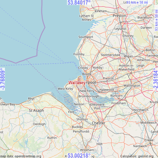
Wallasey GPS coordinates[2]
53° 25' 23.664" North, 3° 3' 53.892" West
| Map corner | latitude | longitude |
|---|---|---|
| Upper-left | 53.84017°, | -3.76809° |
| Center: | 53.42324°, | -3.06497° |
| Lower-right: | 53.00218°, | -2.36184° |
| Map W x H: | 93.2×93.2 km | = 57.9×57.9mi |
| max Lat: | 60.39635° ⇑31.8% North |
| Wallasey: | 53.42324° |
| min Lat: | ⇓68.2% South 34.60088° |
| min Long | Wallasey | max Long |
| -7.64133° | -3.06497° | 32.95536° |
| W 23.4%⇐ | ⇒76.6% E |
Elevation
Elevation of Wallasey is 14 m = 46 ft, and this is 58.9 m = 193 ft below average elevation for this country.
| Max E: |
515 m = 1690 ft | 87% |
| Avg. | 72.9 m = 239 ft | |
| Wallasey | 14 m = 46 ft | |
Min E: |
-30 m = -98 ft | 13% |
See also: Wallasey elevation on elevation.city.
Geographical zone
Wallasey is located in North temperate zone (between Tropic of Cancer and the Arctic Circle). Distance of this North polar circle is 1461.1 km =907.9 mi to North.| Distance of | km | miles | from Wallasey |
|---|---|---|---|
| North Pole | 4067 | 2527.1 | to North |
| Arctic Circle | 1461.1 | 907.9 | to North |
| Tropic Cancer | 3334.2 | 2071.8 | to South |
| Equator | 5940.1 | 3691 | to South |


Nearby cities:
15 places around Wallasey: (largest is in red/bold)
• Bebington
8.8 km =5.5 mi,  158°
158°
• Birkenhead
4.7 km =2.9 mi,  134°
134°
• Bootle
5.8 km =3.6 mi,  33°
33°
• Clubmoor
8.8 km =5.5 mi,  82°
82°
• Crosby
6.4 km =4 mi,  19°
19°
• Greasby
6.8 km =4.2 mi,  214°
214°
• Hoylake
8.5 km =5.3 mi,  244°
244°
• Litherland
6.8 km =4.2 mi,  40°
40°
• Liverpool
5.9 km =3.7 mi,  103°
103°
• Moreton
4.3 km =2.7 mi,  232°
232°
• New Ferry
8.4 km =5.2 mi,  145°
145°
• Prenton
6.2 km =3.9 mi,  173°
173°
• Thornton
9.6 km =6 mi, 26°
• Waterloo
6.2 km =3.9 mi, 21°
• West Kirby
9.7 km =6 mi, 234°
Sources, notices
• [Note1] Compared only with cities in United Kingdom existing in our database
• [Src1] Map data: © OpenStreetMap contributors (CC-BY-SA)
• [Src2] Other city data from geonames.org with taken over terms of usage.
• [Src3] Geographical zone / Annual Mean Temperature by Robert A. Rohde @ Wikipedia
