Birkenhead geodata
Birkenhead (England) is a populated place; located in United Kingdom in Europe/London (GMT+1) time zone. With population of 325,264 people, there are 16 cities with bigger population in this country. Compared to other cities in United Kingdom, 67.8% of cities are located further ↓South; 75.6% of cities are located further →East and 79% of cities have higher elevation than Birkenhead. Note1


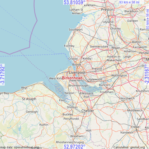
Birkenhead GPS coordinates[2]
53° 23' 36.132" North, 3° 0' 53.244" West
| Map corner | latitude | longitude |
|---|---|---|
| Upper-left | 53.81059°, | -3.71792° |
| Center: | 53.39337°, | -3.01479° |
| Lower-right: | 52.97202°, | -2.31167° |
| Map W x H: | 93.2×93.2 km | = 57.9×57.9mi |
| max Lat: | 60.39635° ⇑32.2% North |
| Birkenhead: | 53.39337° |
| min Lat: | ⇓67.8% South 34.60088° |
| min Long | Birkenhead | max Long |
| -7.64133° | -3.01479° | 32.95536° |
| W 24.4%⇐ | ⇒75.6% E |
Elevation
Elevation of Birkenhead is 22 m = 72 ft, and this is 50.9 m = 167 ft below average elevation for this country.
| Max E: |
515 m = 1690 ft | 79% |
| Avg. | 72.9 m = 239 ft | |
| Birkenhead | 22 m = 72 ft | |
Min E: |
-30 m = -98 ft | 21% |
See also: Birkenhead elevation on elevation.city.
Geographical zone
Birkenhead is located in North temperate zone (between Tropic of Cancer and the Arctic Circle). Distance of this North polar circle is 1464.4 km =909.9 mi to North.| Distance of | km | miles | from Birkenhead |
|---|---|---|---|
| North Pole | 4070.3 | 2529.2 | to North |
| Arctic Circle | 1464.4 | 909.9 | to North |
| Tropic Cancer | 3330.9 | 2069.7 | to South |
| Equator | 5936.8 | 3689 | to South |


Nearby cities:
15 places around Birkenhead: (largest is in red/bold)
• Bebington
4.8 km =3 mi,  181°
181°
• Bootle
8.2 km =5.1 mi,  359°
359°
• Bromborough
5.5 km =3.4 mi,  154°
154°
• Clubmoor
7 km =4.3 mi,  50°
50°
• Crosby
9.5 km =5.9 mi,  352°
352°
• Greasby
7.5 km =4.7 mi,  252°
252°
• Heswall
9.1 km =5.7 mi,  216°
216°
• Litherland
8.6 km =5.3 mi,  7°
7°
• Liverpool
3.1 km =1.9 mi, 51°
• Moreton
6.8 km =4.2 mi,  276°
276°
• New Ferry
3.9 km =2.4 mi,  159°
159°
• Prenton
3.9 km =2.4 mi, 222°
• Wallasey
4.7 km =2.9 mi,  314°
314°
• Waterloo
9.1 km =5.7 mi, 353°
• Willaston
10.9 km =6.8 mi,  173°
173°
Sources, notices
• [Note1] Compared only with cities in United Kingdom existing in our database
• [Src1] Map data: © OpenStreetMap contributors (CC-BY-SA)
• [Src2] Other city data from geonames.org with taken over terms of usage.
• [Src3] Geographical zone / Annual Mean Temperature by Robert A. Rohde @ Wikipedia
