Liverpool geodata
Liverpool (England) is a seat of a second-order administrative division; located in United Kingdom in Europe/London (GMT+1) time zone. With population of 864,122 people, there are 2 cities with bigger population in this country. Compared to other cities in United Kingdom, 68% of cities are located further ↓South; 74.9% of cities are located further →East and 72.3% of cities have higher elevation than Liverpool. Note1


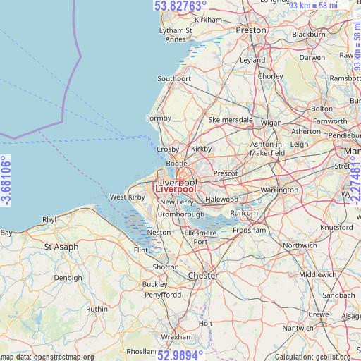
Liverpool GPS coordinates[2]
53° 24' 38.088" North, 2° 58' 40.584" West
| Map corner | latitude | longitude |
|---|---|---|
| Upper-left | 53.82763°, | -3.68106° |
| Center: | 53.41058°, | -2.97794° |
| Lower-right: | 52.9894°, | -2.27481° |
| Map W x H: | 93.2×93.2 km | = 57.9×57.9mi |
| max Lat: | 60.39635° ⇑32% North |
| Liverpool: | 53.41058° |
| min Lat: | ⇓68% South 34.60088° |
| min Long | Liverpool | max Long |
| -7.64133° | -2.97794° | 32.95536° |
| W 25.1%⇐ | ⇒74.9% E |
Elevation
Elevation of Liverpool is 30 m = 98 ft, and this is 42.9 m = 141 ft below average elevation for this country.
| Max E: |
515 m = 1690 ft | 72.3% |
| Avg. | 72.9 m = 239 ft | |
| Liverpool | 30 m = 98 ft | |
Min E: |
-30 m = -98 ft | 27.7% |
See also: Liverpool elevation on elevation.city.
Geographical zone
Liverpool is located in North temperate zone (between Tropic of Cancer and the Arctic Circle). Distance of this North polar circle is 1462.5 km =908.8 mi to North.| Distance of | km | miles | from Liverpool |
|---|---|---|---|
| North Pole | 4068.4 | 2528 | to North |
| Arctic Circle | 1462.5 | 908.8 | to North |
| Tropic Cancer | 3332.8 | 2070.9 | to South |
| Equator | 5938.7 | 3690.1 | to South |


Nearby cities:
15 places around Liverpool: (largest is in red/bold)
• Bebington
7.2 km =4.5 mi,  200°
200°
• Birkenhead
3.1 km =1.9 mi,  231°
231°
• Bootle
6.7 km =4.2 mi,  337°
337°
• Bromborough
6.9 km =4.3 mi,  180°
180°
• Clubmoor
3.9 km =2.4 mi,  49°
49°
• Crosby
8.3 km =5.2 mi,  333°
333°
• Huyton
9.2 km =5.7 mi,  89°
89°
• Knowsley
9.5 km =5.9 mi,  59°
59°
• Litherland
6.7 km =4.2 mi,  348°
348°
• Melling
9 km =5.6 mi,  26°
26°
• Moreton
9.3 km =5.8 mi,  262°
262°
• New Ferry
5.7 km =3.5 mi,  190°
190°
• Prenton
7 km =4.3 mi, 226°
• Wallasey
5.9 km =3.7 mi,  283°
283°
• Waterloo
7.9 km =4.9 mi, 334°
Sources, notices
• [Note1] Compared only with cities in United Kingdom existing in our database
• [Src1] Map data: © OpenStreetMap contributors (CC-BY-SA)
• [Src2] Other city data from geonames.org with taken over terms of usage.
• [Src3] Geographical zone / Annual Mean Temperature by Robert A. Rohde @ Wikipedia
