Bootle geodata
Bootle (England) is a populated place; located in United Kingdom in Europe/London (GMT+1) time zone. With population of 57,791 people, there are 194 cities with bigger population in this country. Compared to other cities in United Kingdom, 69.1% of cities are located further ↓South; 75.7% of cities are located further →East and 85.8% of cities have higher elevation than Bootle. Note1


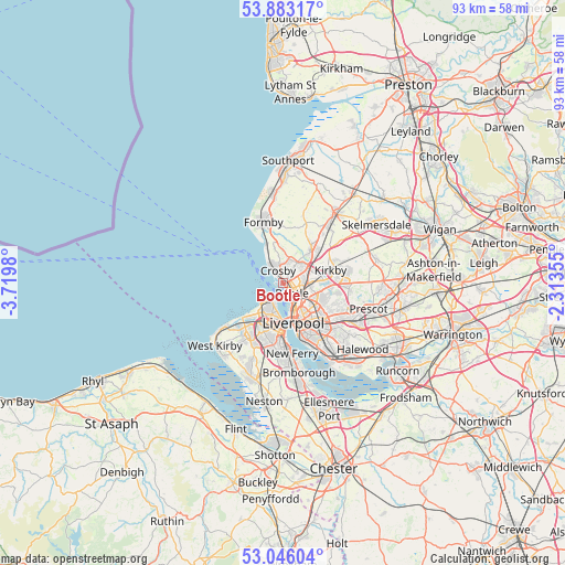
Bootle GPS coordinates[2]
53° 28' 0.012" North, 3° 1' 0.012" West
| Map corner | latitude | longitude |
|---|---|---|
| Upper-left | 53.88317°, | -3.7198° |
| Center: | 53.46667°, | -3.01667° |
| Lower-right: | 53.04604°, | -2.31355° |
| Map W x H: | 93.1×93.1 km | = 57.8×57.8mi |
| max Lat: | 60.39635° ⇑30.9% North |
| Bootle: | 53.46667° |
| min Lat: | ⇓69.1% South 34.60088° |
| min Long | Bootle | max Long |
| -7.64133° | -3.01667° | 32.95536° |
| W 24.3%⇐ | ⇒75.7% E |
Elevation
Elevation of Bootle is 15 m = 49 ft, and this is 57.9 m = 190 ft below average elevation for this country.
| Max E: |
515 m = 1690 ft | 85.8% |
| Avg. | 72.9 m = 239 ft | |
| Bootle | 15 m = 49 ft | |
Min E: |
-30 m = -98 ft | 14.2% |
See also: Bootle elevation on elevation.city.
Geographical zone
Bootle is located in North temperate zone (between Tropic of Cancer and the Arctic Circle). Distance of this North polar circle is 1456.2 km =904.8 mi to North.| Distance of | km | miles | from Bootle |
|---|---|---|---|
| North Pole | 4062.1 | 2524.1 | to North |
| Arctic Circle | 1456.2 | 904.8 | to North |
| Tropic Cancer | 3339 | 2074.8 | to South |
| Equator | 5944.9 | 3694 | to South |


Nearby cities:
15 places around Bootle: (largest is in red/bold)
• Birkenhead
8.2 km =5.1 mi,  179°
179°
• Clubmoor
6.6 km =4.1 mi,  123°
123°
• Crosby
1.7 km =1.1 mi,  318°
318°
• Formby
10.8 km =6.7 mi,  340°
340°
• Hightown
7.1 km =4.4 mi, 335°
• Ince Blundell
6.4 km =4 mi,  353°
353°
• Kirkby
8.4 km =5.2 mi,  78°
78°
• Litherland
1.3 km =0.8 mi,  73°
73°
• Liverpool
6.7 km =4.2 mi,  157°
157°
• Maghull
7.4 km =4.6 mi,  42°
42°
• Melling
6.9 km =4.3 mi, 74°
• Moreton
9.9 km =6.2 mi,  221°
221°
• Thornton
3.9 km =2.4 mi,  16°
16°
• Wallasey
5.8 km =3.6 mi,  213°
213°
• Waterloo
1.3 km =0.8 mi,  314°
314°
Sources, notices
• [Note1] Compared only with cities in United Kingdom existing in our database
• [Src1] Map data: © OpenStreetMap contributors (CC-BY-SA)
• [Src2] Other city data from geonames.org with taken over terms of usage.
• [Src3] Geographical zone / Annual Mean Temperature by Robert A. Rohde @ Wikipedia
