Leysdown-on-Sea geodata
Leysdown-on-Sea (England) is a populated place; located in United Kingdom in Europe/London (GMT+1) time zone. With population of 3,019 people, there are 2122 cities with bigger population in this country. Compared to other cities in United Kingdom, 81% of cities are located further ↑North; 95.9% of cities are located further ←West and 89.9% of cities have higher elevation than Leysdown-on-Sea. Note1
Administrative division(s):
- Level 1: England
- Level 2: Kent
- Level 3: Swale District
- Level 4: Leysdown


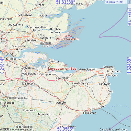
Leysdown-on-Sea GPS coordinates[2]
51° 23' 50.28" North, 0° 55' 17.616" East
| Map corner | latitude | longitude |
|---|---|---|
| Upper-left | 51.83389°, | 0.21844° |
| Center: | 51.3973°, | 0.92156° |
| Lower-right: | 50.9565°, | 1.62469° |
| Map W x H: | 97.6×97.6 km | = 60.6×60.6mi |
| max Lat: | 60.39635° ⇑81% North |
| Leysdown-on-Sea: | 51.3973° |
| min Lat: | ⇓19% South 34.60088° |
| min Long | Leysdown-on-Sea | max Long |
| -7.64133° | 0.92156° | 32.95536° |
| W 95.9%⇐ | ⇒4.1% E |
Elevation
Elevation of Leysdown-on-Sea is 12 m = 39 ft, and this is 60.9 m = 200 ft below average elevation for this country.
| Max E: |
515 m = 1690 ft | 89.9% |
| Avg. | 72.9 m = 239 ft | |
| Leysdown-on-Sea | 12 m = 39 ft | |
Min E: |
-30 m = -98 ft | 10.1% |
See also: United Kingdom elevation on elevation.city.
Geographical zone
Leysdown-on-Sea is located in North temperate zone (between Tropic of Cancer and the Arctic Circle). Distance of this North polar circle is 1686.3 km =1047.8 mi to North.| Distance of | km | miles | from Leysdown-on-Sea |
|---|---|---|---|
| North Pole | 4292.2 | 2667 | to North |
| Arctic Circle | 1686.3 | 1047.8 | to North |
| Tropic Cancer | 3108.9 | 1931.8 | to South |
| Equator | 5714.8 | 3551 | to South |


Nearby cities:
15 places around Leysdown-on-Sea: (largest is in red/bold)
• Blean
13.1 km =8.1 mi,  140°
140°
• Borden
16.9 km =10.5 mi,  245°
245°
• Canterbury
17.1 km =10.6 mi, 140°
• Eastchurch
4.6 km =2.9 mi,  283°
283°
• Faversham
9.5 km =5.9 mi,  194°
194°
• Grain
16 km =9.9 mi,  294°
294°
• Herne Bay
14.6 km =9.1 mi,  100°
100°
• Iwade
13.5 km =8.4 mi,  260°
260°
• Lynsted
13.3 km =8.3 mi,  224°
224°
• Queenborough
12.5 km =7.8 mi, 280°
• Sheerness
12 km =7.5 mi, 293°
• Sittingbourne
14.5 km =9 mi,  244°
244°
• Tankerton
9.6 km =6 mi,  112°
112°
• Teynham
11 km =6.8 mi,  227°
227°
• Whitstable
8.3 km =5.2 mi,  119°
119°
Sources, notices
• [Note1] Compared only with cities in United Kingdom existing in our database
• [Src1] Map data: © OpenStreetMap contributors (CC-BY-SA)
• [Src2] Other city data from geonames.org with taken over terms of usage.
• [Src3] Geographical zone / Annual Mean Temperature by Robert A. Rohde @ Wikipedia
