Settle geodata
Settle (England) is a populated place; located in United Kingdom in Europe/London (GMT+1) time zone. With population of 3,659 people, there are 1938 cities with bigger population in this country. Compared to other cities in United Kingdom, 79% of cities are located further ↓South; 60.8% of cities are located further →East and 91.6% of cities have lower elevation than Settle. Note1
Administrative division(s):
- Level 1: England
- Level 2: North Yorkshire
- Level 3: Craven District
- Level 4: Settle


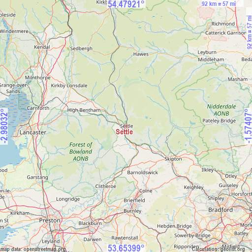
Settle GPS coordinates[2]
54° 4' 7.14" North, 2° 16' 37.92" West
| Map corner | latitude | longitude |
|---|---|---|
| Upper-left | 54.47921°, | -2.98032° |
| Center: | 54.06865°, | -2.2772° |
| Lower-right: | 53.65399°, | -1.57407° |
| Map W x H: | 91.8×91.8 km | = 57×57mi |
| max Lat: | 60.39635° ⇑21% North |
| Settle: | 54.06865° |
| min Lat: | ⇓79% South 34.60088° |
| min Long | Settle | max Long |
| -7.64133° | -2.2772° | 32.95536° |
| W 39.2%⇐ | ⇒60.8% E |
Elevation
Elevation of Settle is 158 m = 518 ft, and this is 85.1 m = 279 ft above average elevation for this country.
| Max E: |
515 m = 1690 ft | 8.4% |
| Settle | 158 m 518 ft | |
| Avg. | 72.9 m = 239 ft | |
Min E: |
-30 m = -98 ft | 91.6% |
See also: United Kingdom elevation on elevation.city.
Geographical zone
Settle is located in North temperate zone (between Tropic of Cancer and the Arctic Circle). Distance of this North polar circle is 1389.3 km =863.3 mi to North.| Distance of | km | miles | from Settle |
|---|---|---|---|
| North Pole | 3995.2 | 2482.5 | to North |
| Arctic Circle | 1389.3 | 863.3 | to North |
| Tropic Cancer | 3406 | 2116.4 | to South |
| Equator | 6011.9 | 3735.6 | to South |


Nearby cities:
15 places around Settle: (largest is in red/bold)
• Barnoldswick
17.9 km =11.1 mi,  160°
160°
• Burton in Lonsdale
18.7 km =11.6 mi,  296°
296°
• Chatburn
20.3 km =12.6 mi,  194°
194°
• Earby
19.2 km =11.9 mi,  152°
152°
• Gargrave
14.7 km =9.1 mi,  130°
130°
• Gisburn
14.9 km =9.3 mi,  176°
176°
• Grassington
18.2 km =11.3 mi,  89°
89°
• Hellifield
7.9 km =4.9 mi, 153°
• Hetton
15 km =9.3 mi,  108°
108°
• High Bentham
16.3 km =10.1 mi,  289°
289°
• Ingleton
15.7 km =9.8 mi,  307°
307°
• Kelbrook
20.7 km =12.9 mi, 156°
• Long Preston
5.6 km =3.5 mi,  166°
166°
• Otterburn
8.6 km =5.3 mi, 132°
• Winterburn
12.5 km =7.8 mi, 113°
Sources, notices
• [Note1] Compared only with cities in United Kingdom existing in our database
• [Src1] Map data: © OpenStreetMap contributors (CC-BY-SA)
• [Src2] Other city data from geonames.org with taken over terms of usage.
• [Src3] Geographical zone / Annual Mean Temperature by Robert A. Rohde @ Wikipedia
