Newquay geodata
Newquay (England) is a seat of a third-order administrative division; located in United Kingdom in Europe/London (GMT+1) time zone. With population of 20,189 people, there are 585 cities with bigger population in this country. Compared to other cities in United Kingdom, 98.4% of cities are located further ↑North; 96.5% of cities are located further →East and 71.6% of cities have higher elevation than Newquay. Note1


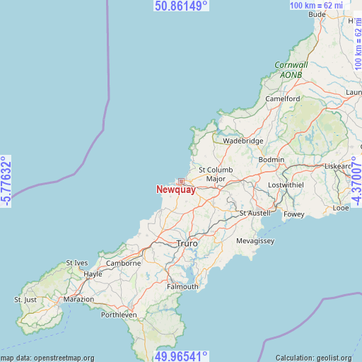
Newquay GPS coordinates[2]
50° 24' 56.052" North, 5° 4' 23.484" West
| Map corner | latitude | longitude |
|---|---|---|
| Upper-left | 50.86149°, | -5.77632° |
| Center: | 50.41557°, | -5.07319° |
| Lower-right: | 49.96541°, | -4.37007° |
| Map W x H: | 99.6×99.6 km | = 61.9×61.9mi |
| max Lat: | 60.39635° ⇑98.4% North |
| Newquay: | 50.41557° |
| min Lat: | ⇓1.6% South 34.60088° |
| min Long | Newquay | max Long |
| -7.64133° | -5.07319° | 32.95536° |
| W 3.5%⇐ | ⇒96.5% E |
Elevation
Elevation of Newquay is 31 m = 102 ft, and this is 41.9 m = 137 ft below average elevation for this country.
| Max E: |
515 m = 1690 ft | 71.6% |
| Avg. | 72.9 m = 239 ft | |
| Newquay | 31 m = 102 ft | |
Min E: |
-30 m = -98 ft | 28.4% |
See also: United Kingdom elevation on elevation.city.
Geographical zone
Newquay is located in North temperate zone (between Tropic of Cancer and the Arctic Circle). Distance of this North polar circle is 1795.5 km =1115.7 mi to North.| Distance of | km | miles | from Newquay |
|---|---|---|---|
| North Pole | 4401.4 | 2734.9 | to North |
| Arctic Circle | 1795.5 | 1115.7 | to North |
| Tropic Cancer | 2999.8 | 1864 | to South |
| Equator | 5605.7 | 3483.2 | to South |


Nearby cities:
15 places around Newquay: (largest is in red/bold)
• Chacewater
18.6 km =11.6 mi,  198°
198°
• Crantock
3.1 km =1.9 mi,  242°
242°
• Cubert
5.1 km =3.2 mi,  218°
218°
• Grampound
17.8 km =11.1 mi,  136°
136°
• Mount Hawke
17.7 km =11 mi,  212°
212°
• Nanpean
15.4 km =9.6 mi,  109°
109°
• Padstow
16.8 km =10.4 mi,  35°
35°
• Perranporth
9.9 km =6.2 mi, 216°
• Probus
16.1 km =10 mi,  148°
148°
• Roche
17 km =10.6 mi,  92°
92°
• Saint Agnes
14.7 km =9.1 mi, 219°
• Saint Columb Major
9.4 km =5.8 mi,  79°
79°
• Saint Dennis
13.9 km =8.6 mi,  104°
104°
• Saint Stephen
14.6 km =9.1 mi,  122°
122°
• Truro
16.8 km =10.4 mi,  175°
175°
Sources, notices
• [Note1] Compared only with cities in United Kingdom existing in our database
• [Src1] Map data: © OpenStreetMap contributors (CC-BY-SA)
• [Src2] Other city data from geonames.org with taken over terms of usage.
• [Src3] Geographical zone / Annual Mean Temperature by Robert A. Rohde @ Wikipedia
