Runcorn geodata
Runcorn (England) is a populated place; located in United Kingdom in Europe/London (GMT+1) time zone. With population of 62,872 people, there are 172 cities with bigger population in this country. Compared to other cities in United Kingdom, 66.8% of cities are located further ↓South; 69.4% of cities are located further →East and 82.8% of cities have higher elevation than Runcorn. Note1


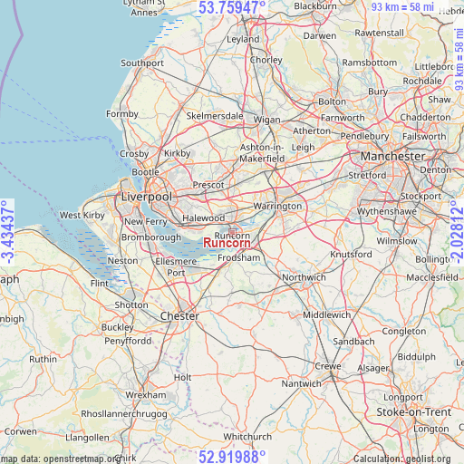
Runcorn GPS coordinates[2]
53° 20' 30.264" North, 2° 43' 52.464" West
| Map corner | latitude | longitude |
|---|---|---|
| Upper-left | 53.75947°, | -3.43437° |
| Center: | 53.34174°, | -2.73124° |
| Lower-right: | 52.91988°, | -2.02812° |
| Map W x H: | 93.4×93.4 km | = 58×58mi |
| max Lat: | 60.39635° ⇑33.2% North |
| Runcorn: | 53.34174° |
| min Lat: | ⇓66.8% South 34.60088° |
| min Long | Runcorn | max Long |
| -7.64133° | -2.73124° | 32.95536° |
| W 30.6%⇐ | ⇒69.4% E |
Elevation
Elevation of Runcorn is 18 m = 59 ft, and this is 54.9 m = 180 ft below average elevation for this country.
| Max E: |
515 m = 1690 ft | 82.8% |
| Avg. | 72.9 m = 239 ft | |
| Runcorn | 18 m = 59 ft | |
Min E: |
-30 m = -98 ft | 17.2% |
See also: Runcorn elevation on elevation.city.
Geographical zone
Runcorn is located in North temperate zone (between Tropic of Cancer and the Arctic Circle). Distance of this North polar circle is 1470.1 km =913.5 mi to North.| Distance of | km | miles | from Runcorn |
|---|---|---|---|
| North Pole | 4076 | 2532.7 | to North |
| Arctic Circle | 1470.1 | 913.5 | to North |
| Tropic Cancer | 3325.1 | 2066.1 | to South |
| Equator | 5931 | 3685.4 | to South |


Nearby cities:
15 places around Runcorn: (largest is in red/bold)
• Appleton
10.6 km =6.6 mi,  83°
83°
• Burtonwood
10.9 km =6.8 mi,  26°
26°
• Daresbury
6.4 km =4 mi,  89°
89°
• Elton
10.1 km =6.3 mi,  214°
214°
• Frodsham
5.2 km =3.2 mi,  177°
177°
• Great Sankey
8.3 km =5.2 mi,  47°
47°
• Hale
4.7 km =2.9 mi,  258°
258°
• Halton
3.5 km =2.2 mi,  143°
143°
• Helsby
7.9 km =4.9 mi,  198°
198°
• Huyton
10.6 km =6.6 mi,  317°
317°
• Ince
9.4 km =5.8 mi,  226°
226°
• Kingsley
9.4 km =5.8 mi,  152°
152°
• Prescot
10.8 km =6.7 mi,  334°
334°
• Whiston
9.5 km =5.9 mi,  336°
336°
• Widnes
2.2 km =1.4 mi,  355°
355°
Sources, notices
• [Note1] Compared only with cities in United Kingdom existing in our database
• [Src1] Map data: © OpenStreetMap contributors (CC-BY-SA)
• [Src2] Other city data from geonames.org with taken over terms of usage.
• [Src3] Geographical zone / Annual Mean Temperature by Robert A. Rohde @ Wikipedia
