Prescot geodata
Prescot (England) is a seat of a third-order administrative division; located in United Kingdom in Europe/London (GMT+1) time zone. With population of 40,889 people, there are 300 cities with bigger population in this country. Compared to other cities in United Kingdom, 68.3% of cities are located further ↓South; 71% of cities are located further →East and 62.7% of cities have lower elevation than Prescot. Note1


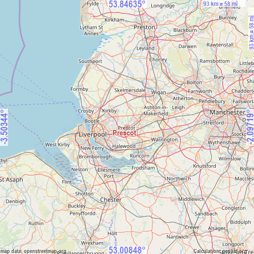
Prescot GPS coordinates[2]
53° 25' 46.128" North, 2° 48' 1.116" West
| Map corner | latitude | longitude |
|---|---|---|
| Upper-left | 53.84635°, | -3.50344° |
| Center: | 53.42948°, | -2.80031° |
| Lower-right: | 53.00848°, | -2.09719° |
| Map W x H: | 93.2×93.2 km | = 57.9×57.9mi |
| max Lat: | 60.39635° ⇑31.7% North |
| Prescot: | 53.42948° |
| min Lat: | ⇓68.3% South 34.60088° |
| min Long | Prescot | max Long |
| -7.64133° | -2.80031° | 32.95536° |
| W 29%⇐ | ⇒71% E |
Elevation
Elevation of Prescot is 81 m = 266 ft, and this is 8.1 m = 27 ft above average elevation for this country.
| Max E: |
515 m = 1690 ft | 37.3% |
| Prescot | 81 m 266 ft | |
| Avg. | 72.9 m = 239 ft | |
Min E: |
-30 m = -98 ft | 62.7% |
See also: Prescot elevation on elevation.city.
Geographical zone
Prescot is located in North temperate zone (between Tropic of Cancer and the Arctic Circle). Distance of this North polar circle is 1460.4 km =907.5 mi to North.| Distance of | km | miles | from Prescot |
|---|---|---|---|
| North Pole | 4066.3 | 2526.7 | to North |
| Arctic Circle | 1460.4 | 907.5 | to North |
| Tropic Cancer | 3334.9 | 2072.2 | to South |
| Equator | 5940.8 | 3691.4 | to South |


Nearby cities:
15 places around Prescot: (largest is in red/bold)
• Billinge
9.8 km =6.1 mi,  38°
38°
• Burtonwood
9.4 km =5.8 mi,  90°
90°
• Clubmoor
8.8 km =5.5 mi,  272°
272°
• Eccleston
2.5 km =1.6 mi,  26°
26°
• Hale
10.7 km =6.6 mi,  179°
179°
• Haydock
8.9 km =5.5 mi,  61°
61°
• Huyton
3.3 km =2.1 mi,  232°
232°
• Kirkby
8.4 km =5.2 mi,  313°
313°
• Knowsley
4.5 km =2.8 mi, 307°
• Melling
9.8 km =6.1 mi, 307°
• Rainford
8.1 km =5 mi,  5°
5°
• Runcorn
10.8 km =6.7 mi,  154°
154°
• St Helens
5 km =3.1 mi, 62°
• Whiston
1.3 km =0.8 mi,  144°
144°
• Widnes
8.7 km =5.4 mi, 149°
Sources, notices
• [Note1] Compared only with cities in United Kingdom existing in our database
• [Src1] Map data: © OpenStreetMap contributors (CC-BY-SA)
• [Src2] Other city data from geonames.org with taken over terms of usage.
• [Src3] Geographical zone / Annual Mean Temperature by Robert A. Rohde @ Wikipedia
