Widnes geodata
Widnes (England) is a seat of a second-order administrative division; located in United Kingdom in Europe/London (GMT+1) time zone. With population of 61,464 people, there are 176 cities with bigger population in this country. Compared to other cities in United Kingdom, 67.2% of cities are located further ↓South; 69.5% of cities are located further →East and 88.2% of cities have higher elevation than Widnes. Note1


Widnes GPS coordinates[2]
53° 21' 42.48" North, 2° 44' 2.616" West
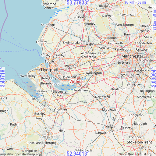
| Map corner | latitude | longitude |
|---|---|---|
| Upper-left | 53.77933°, | -3.43719° |
| Center: | 53.3618°, | -2.73406° |
| Lower-right: | 52.94013°, | -2.03094° |
| Map W x H: | 93.3×93.3 km | = 58×58mi |
| max Lat: | 60.39635° ⇑32.8% North |
| Widnes: | 53.3618° |
| min Lat: | ⇓67.2% South 34.60088° |
| min Long | Widnes | max Long |
| -7.64133° | -2.73406° | 32.95536° |
| W 30.5%⇐ | ⇒69.5% E |
Elevation
Elevation of Widnes is 13 m = 43 ft, and this is 59.9 m = 197 ft below average elevation for this country.
| Max E: |
515 m = 1690 ft | 88.2% |
| Avg. | 72.9 m = 239 ft | |
| Widnes | 13 m = 43 ft | |
Min E: |
-30 m = -98 ft | 11.8% |
See also: Widnes elevation on elevation.city.
Geographical zone
Widnes is located in North temperate zone (between Tropic of Cancer and the Arctic Circle). Distance of this North polar circle is 1467.9 km =912.1 mi to North.| Distance of | km | miles | from Widnes |
|---|---|---|---|
| North Pole | 4073.8 | 2531.3 | to North |
| Arctic Circle | 1467.9 | 912.1 | to North |
| Tropic Cancer | 3327.4 | 2067.5 | to South |
| Equator | 5933.3 | 3686.8 | to South |


Nearby cities:
15 places around Widnes: (largest is in red/bold)
• Burtonwood
9 km =5.6 mi,  33°
33°
• Daresbury
6.9 km =4.3 mi,  108°
108°
• Eccleston
10.3 km =6.4 mi,  341°
341°
• Frodsham
7.5 km =4.7 mi,  176°
176°
• Great Sankey
7.1 km =4.4 mi,  61°
61°
• Hale
5.4 km =3.4 mi,  234°
234°
• Halton
5.5 km =3.4 mi,  155°
155°
• Helsby
10 km =6.2 mi,  193°
193°
• Huyton
8.9 km =5.5 mi,  308°
308°
• Prescot
8.7 km =5.4 mi,  329°
329°
• Runcorn
2.2 km =1.4 mi, 175°
• St Helens
9.8 km =6.1 mi,  0°
0°
• Stockton Heath
10.7 km =6.6 mi,  84°
84°
• Warrington
10.8 km =6.7 mi,  71°
71°
• Whiston
7.4 km =4.6 mi, 330°
Sources, notices
• [Note1] Compared only with cities in United Kingdom existing in our database
• [Src1] Map data: © OpenStreetMap contributors (CC-BY-SA)
• [Src2] Other city data from geonames.org with taken over terms of usage.
• [Src3] Geographical zone / Annual Mean Temperature by Robert A. Rohde @ Wikipedia
