Huyton geodata
Huyton (England) is a populated place; located in United Kingdom in Europe/London (GMT+1) time zone. With population of 54,738 people, there are 210 cities with bigger population in this country. Compared to other cities in United Kingdom, 68% of cities are located further ↓South; 72% of cities are located further →East and 64.9% of cities have higher elevation than Huyton. Note1


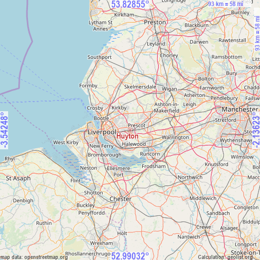
Huyton GPS coordinates[2]
53° 24' 41.4" North, 2° 50' 21.66" West
| Map corner | latitude | longitude |
|---|---|---|
| Upper-left | 53.82855°, | -3.54248° |
| Center: | 53.4115°, | -2.83935° |
| Lower-right: | 52.99032°, | -2.13623° |
| Map W x H: | 93.2×93.2 km | = 57.9×57.9mi |
| max Lat: | 60.39635° ⇑32% North |
| Huyton: | 53.4115° |
| min Lat: | ⇓68% South 34.60088° |
| min Long | Huyton | max Long |
| -7.64133° | -2.83935° | 32.95536° |
| W 28%⇐ | ⇒72% E |
Elevation
Elevation of Huyton is 40 m = 131 ft, and this is 32.9 m = 108 ft below average elevation for this country.
| Max E: |
515 m = 1690 ft | 64.9% |
| Avg. | 72.9 m = 239 ft | |
| Huyton | 40 m = 131 ft | |
Min E: |
-30 m = -98 ft | 35.1% |
See also: Huyton elevation on elevation.city.
Geographical zone
Huyton is located in North temperate zone (between Tropic of Cancer and the Arctic Circle). Distance of this North polar circle is 1462.4 km =908.7 mi to North.| Distance of | km | miles | from Huyton |
|---|---|---|---|
| North Pole | 4068.3 | 2527.9 | to North |
| Arctic Circle | 1462.4 | 908.7 | to North |
| Tropic Cancer | 3332.9 | 2071 | to South |
| Equator | 5938.8 | 3690.2 | to South |


Nearby cities:
15 places around Huyton: (largest is in red/bold)
• Bromborough
11.6 km =7.2 mi,  232°
232°
• Clubmoor
6.7 km =4.2 mi,  291°
291°
• Eccleston
5.7 km =3.5 mi,  40°
40°
• Hale
9.1 km =5.7 mi,  163°
163°
• Kirkby
8.5 km =5.3 mi,  335°
335°
• Knowsley
4.8 km =3 mi,  348°
348°
• Liverpool
9.2 km =5.7 mi,  269°
269°
• Melling
9.5 km =5.9 mi,  327°
327°
• New Ferry
11.7 km =7.3 mi,  241°
241°
• Prescot
3.3 km =2.1 mi,  52°
52°
• Rainford
10.6 km =6.6 mi,  18°
18°
• Runcorn
10.6 km =6.6 mi,  137°
137°
• St Helens
8.2 km =5.1 mi,  58°
58°
• Whiston
3.5 km =2.2 mi,  74°
74°
• Widnes
8.9 km =5.5 mi,  128°
128°
Sources, notices
• [Note1] Compared only with cities in United Kingdom existing in our database
• [Src1] Map data: © OpenStreetMap contributors (CC-BY-SA)
• [Src2] Other city data from geonames.org with taken over terms of usage.
• [Src3] Geographical zone / Annual Mean Temperature by Robert A. Rohde @ Wikipedia
