Trefriw geodata
Trefriw (Wales) is a populated place; located in United Kingdom in Europe/London (GMT+1) time zone. With population of 605 people, there are 4557 cities with bigger population in this country. Compared to other cities in United Kingdom, 63.1% of cities are located further ↓South; 86% of cities are located further →East and 71.6% of cities have higher elevation than Trefriw. Note1


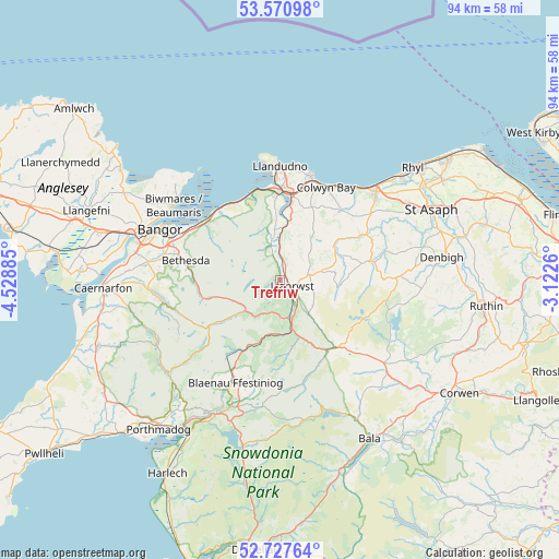
Trefriw GPS coordinates[2]
53° 9' 4.968" North, 3° 49' 32.628" West
| Map corner | latitude | longitude |
|---|---|---|
| Upper-left | 53.57098°, | -4.52885° |
| Center: | 53.15138°, | -3.82573° |
| Lower-right: | 52.72764°, | -3.1226° |
| Map W x H: | 93.8×93.8 km | = 58.3×58.3mi |
| max Lat: | 60.39635° ⇑36.9% North |
| Trefriw: | 53.15138° |
| min Lat: | ⇓63.1% South 34.60088° |
| min Long | Trefriw | max Long |
| -7.64133° | -3.82573° | 32.95536° |
| W 14%⇐ | ⇒86% E |
Elevation
Elevation of Trefriw is 31 m = 102 ft, and this is 41.9 m = 137 ft below average elevation for this country.
| Max E: |
515 m = 1690 ft | 71.6% |
| Avg. | 72.9 m = 239 ft | |
| Trefriw | 31 m = 102 ft | |
Min E: |
-30 m = -98 ft | 28.4% |
See also: United Kingdom elevation on elevation.city.
Geographical zone
Trefriw is located in North temperate zone (between Tropic of Cancer and the Arctic Circle). Distance of this North polar circle is 1491.3 km =926.7 mi to North.| Distance of | km | miles | from Trefriw |
|---|---|---|---|
| North Pole | 4097.2 | 2545.9 | to North |
| Arctic Circle | 1491.3 | 926.7 | to North |
| Tropic Cancer | 3304 | 2053 | to South |
| Equator | 5909.9 | 3672.2 | to South |


Nearby cities:
15 places around Trefriw: (largest is in red/bold)
• Aber
15.6 km =9.7 mi,  305°
305°
• Bethesda
15.9 km =9.9 mi,  282°
282°
• Betws-y-Coed
6.5 km =4 mi,  168°
168°
• Blaenau-Ffestiniog
18.9 km =11.7 mi,  203°
203°
• Colwyn Bay
17.3 km =10.7 mi,  22°
22°
• Conwy
14.4 km =8.9 mi,  358°
358°
• Deganwy
17 km =10.6 mi, 359°
• Llandudno
19.3 km =12 mi, 358°
• Llanfairfechan
15.4 km =9.6 mi,  320°
320°
• Llanrwst
2.4 km =1.5 mi,  121°
121°
• Llansantffraid Glan Conwy
12.9 km =8 mi,  7°
7°
• Llysfaen
18.1 km =11.2 mi,  35°
35°
• Mochdre
15.5 km =9.6 mi, 18°
• Penmaenmawr
14.7 km =9.1 mi,  330°
330°
• Tregarth
18 km =11.2 mi, 283°
Sources, notices
• [Note1] Compared only with cities in United Kingdom existing in our database
• [Src1] Map data: © OpenStreetMap contributors (CC-BY-SA)
• [Src2] Other city data from geonames.org with taken over terms of usage.
• [Src3] Geographical zone / Annual Mean Temperature by Robert A. Rohde @ Wikipedia
