Odiham geodata
Odiham (England) is a populated place; located in United Kingdom in Europe/London (GMT+1) time zone. With population of 3,165 people, there are 2067 cities with bigger population in this country. Compared to other cities in United Kingdom, 85.5% of cities are located further ↑North; 67.8% of cities are located further ←West and 70.3% of cities have lower elevation than Odiham. Note1
Administrative division(s):
- Level 1: England
- Level 2: Hampshire
- Level 3: Hart District
- Level 4: Odiham


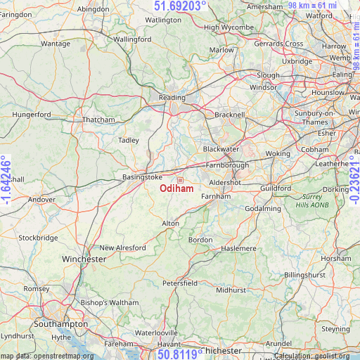
Odiham GPS coordinates[2]
51° 15' 14.652" North, 0° 56' 21.588" West
| Map corner | latitude | longitude |
|---|---|---|
| Upper-left | 51.69203°, | -1.64246° |
| Center: | 51.25407°, | -0.93933° |
| Lower-right: | 50.8119°, | -0.23621° |
| Map W x H: | 97.9×97.9 km | = 60.8×60.8mi |
| max Lat: | 60.39635° ⇑85.5% North |
| Odiham: | 51.25407° |
| min Lat: | ⇓14.5% South 34.60088° |
| min Long | Odiham | max Long |
| -7.64133° | -0.93933° | 32.95536° |
| W 67.8%⇐ | ⇒32.2% E |
Elevation
Elevation of Odiham is 96 m = 315 ft, and this is 23.1 m = 76 ft above average elevation for this country.
| Max E: |
515 m = 1690 ft | 29.7% |
| Odiham | 96 m 315 ft | |
| Avg. | 72.9 m = 239 ft | |
Min E: |
-30 m = -98 ft | 70.3% |
See also: United Kingdom elevation on elevation.city.
Geographical zone
Odiham is located in North temperate zone (between Tropic of Cancer and the Arctic Circle). Distance of this North polar circle is 1702.3 km =1057.8 mi to North.| Distance of | km | miles | from Odiham |
|---|---|---|---|
| North Pole | 4308.1 | 2676.9 | to North |
| Arctic Circle | 1702.3 | 1057.8 | to North |
| Tropic Cancer | 3093 | 1921.9 | to South |
| Equator | 5698.9 | 3541.1 | to South |


Nearby cities:
15 places around Odiham: (largest is in red/bold)
• Aldershot
12.2 km =7.6 mi,  93°
93°
• Alton
11.9 km =7.4 mi,  191°
191°
• Basingstoke
10.3 km =6.4 mi,  275°
275°
• Bramley
11.6 km =7.2 mi,  314°
314°
• Crondall
5.8 km =3.6 mi,  114°
114°
• Eversley
11.6 km =7.2 mi,  17°
17°
• Farnham
10.6 km =6.6 mi, 114°
• Fleet
8.1 km =5 mi,  66°
66°
• Hale
10.8 km =6.7 mi,  104°
104°
• Hartley Wintney
6.2 km =3.9 mi,  26°
26°
• Hook
3.6 km =2.2 mi,  337°
337°
• Long Sutton
3.8 km =2.4 mi,  183°
183°
• Old Basing
6.7 km =4.2 mi, 282°
• Rotherwick
5.8 km =3.6 mi, 338°
• Yateley
12.5 km =7.8 mi,  37°
37°
Sources, notices
• [Note1] Compared only with cities in United Kingdom existing in our database
• [Src1] Map data: © OpenStreetMap contributors (CC-BY-SA)
• [Src2] Other city data from geonames.org with taken over terms of usage.
• [Src3] Geographical zone / Annual Mean Temperature by Robert A. Rohde @ Wikipedia
