Long Sutton geodata
Long Sutton (England) is a populated place; located in United Kingdom in Europe/London (GMT+1) time zone. With population of 4,633 people, there are 1716 cities with bigger population in this country. Compared to other cities in United Kingdom, 86.3% of cities are located further ↑North; 67.7% of cities are located further ←West and 82.5% of cities have lower elevation than Long Sutton. Note1
Administrative division(s):
- Level 1: England
- Level 2: Hampshire
- Level 3: Hart District
- Level 4: Long Sutton


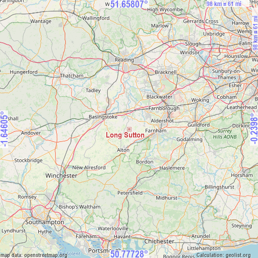
Long Sutton GPS coordinates[2]
51° 13' 11.208" North, 0° 56' 34.548" West
| Map corner | latitude | longitude |
|---|---|---|
| Upper-left | 51.65807°, | -1.64605° |
| Center: | 51.21978°, | -0.94293° |
| Lower-right: | 50.77728°, | -0.2398° |
| Map W x H: | 97.9×97.9 km | = 60.8×60.8mi |
| max Lat: | 60.39635° ⇑86.3% North |
| Long Sutton: | 51.21978° |
| min Lat: | ⇓13.7% South 34.60088° |
| min Long | Long Sutton | max Long |
| -7.64133° | -0.94293° | 32.95536° |
| W 67.7%⇐ | ⇒32.3% E |
Elevation
Elevation of Long Sutton is 125 m = 410 ft, and this is 52.1 m = 171 ft above average elevation for this country.
| Max E: |
515 m = 1690 ft | 17.5% |
| Long Sutton | 125 m 410 ft | |
| Avg. | 72.9 m = 239 ft | |
Min E: |
-30 m = -98 ft | 82.5% |
See also: United Kingdom elevation on elevation.city.
Geographical zone
Long Sutton is located in North temperate zone (between Tropic of Cancer and the Arctic Circle). Distance of this North polar circle is 1706.1 km =1060.1 mi to North.| Distance of | km | miles | from Long Sutton |
|---|---|---|---|
| North Pole | 4312 | 2679.4 | to North |
| Arctic Circle | 1706.1 | 1060.1 | to North |
| Tropic Cancer | 3089.2 | 1919.5 | to South |
| Equator | 5695.1 | 3538.8 | to South |


Nearby cities:
15 places around Long Sutton: (largest is in red/bold)
• Aldershot
12.9 km =8 mi,  75°
75°
• Alton
8.1 km =5 mi,  195°
195°
• Basingstoke
11.1 km =6.9 mi,  295°
295°
• Bentworth
10.3 km =6.4 mi,  227°
227°
• Crondall
5.7 km =3.5 mi, 75°
• Farnham
9.9 km =6.2 mi,  93°
93°
• Fleet
10.4 km =6.5 mi,  47°
47°
• Hale
10.8 km =6.7 mi, 84°
• Hartley Wintney
9.8 km =6.1 mi,  17°
17°
• Hook
7.3 km =4.5 mi,  350°
350°
• Kingsley
10.2 km =6.3 mi,  153°
153°
• Lindford
13.1 km =8.1 mi, 149°
• Odiham
3.8 km =2.4 mi,  3°
3°
• Old Basing
8.2 km =5.1 mi,  309°
309°
• Rotherwick
9.4 km =5.8 mi, 348°
Sources, notices
• [Note1] Compared only with cities in United Kingdom existing in our database
• [Src1] Map data: © OpenStreetMap contributors (CC-BY-SA)
• [Src2] Other city data from geonames.org with taken over terms of usage.
• [Src3] Geographical zone / Annual Mean Temperature by Robert A. Rohde @ Wikipedia
