Basingstoke geodata
Basingstoke (England) is a populated place; located in United Kingdom in Europe/London (GMT+1) time zone. With population of 107,642 people, there are 87 cities with bigger population in this country. Compared to other cities in United Kingdom, 85.2% of cities are located further ↑North; 64.9% of cities are located further ←West and 70.3% of cities have lower elevation than Basingstoke. Note1
Administrative division(s):
- Level 1: England
- Level 2: Hampshire
- Level 3: Basingstoke and Deane District


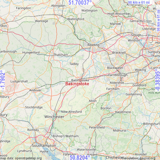
Basingstoke GPS coordinates[2]
51° 15' 44.964" North, 1° 5' 13.488" West
| Map corner | latitude | longitude |
|---|---|---|
| Upper-left | 51.70037°, | -1.7902° |
| Center: | 51.26249°, | -1.08708° |
| Lower-right: | 50.8204°, | -0.38395° |
| Map W x H: | 97.8×97.8 km | = 60.8×60.8mi |
| max Lat: | 60.39635° ⇑85.2% North |
| Basingstoke: | 51.26249° |
| min Lat: | ⇓14.8% South 34.60088° |
| min Long | Basingstoke | max Long |
| -7.64133° | -1.08708° | 32.95536° |
| W 64.9%⇐ | ⇒35.1% E |
Elevation
Elevation of Basingstoke is 96 m = 315 ft, and this is 23.1 m = 76 ft above average elevation for this country.
| Max E: |
515 m = 1690 ft | 29.7% |
| Basingstoke | 96 m 315 ft | |
| Avg. | 72.9 m = 239 ft | |
Min E: |
-30 m = -98 ft | 70.3% |
See also: Basingstoke elevation on elevation.city.
Geographical zone
Basingstoke is located in North temperate zone (between Tropic of Cancer and the Arctic Circle). Distance of this North polar circle is 1701.3 km =1057.1 mi to North.| Distance of | km | miles | from Basingstoke |
|---|---|---|---|
| North Pole | 4307.2 | 2676.4 | to North |
| Arctic Circle | 1701.3 | 1057.1 | to North |
| Tropic Cancer | 3093.9 | 1922.5 | to South |
| Equator | 5699.9 | 3541.8 | to South |


Nearby cities:
15 places around Basingstoke: (largest is in red/bold)
• Bentworth
12 km =7.5 mi,  168°
168°
• Bramley
7.4 km =4.6 mi,  15°
15°
• Hook
9.2 km =5.7 mi,  74°
74°
• Kingsclere
12.9 km =8 mi,  302°
302°
• Long Sutton
11.1 km =6.9 mi,  115°
115°
• North Waltham
9.4 km =5.8 mi,  233°
233°
• Odiham
10.3 km =6.4 mi,  95°
95°
• Old Basing
3.8 km =2.4 mi,  82°
82°
• Overton
12.3 km =7.6 mi,  260°
260°
• Preston Candover
10.7 km =6.6 mi,  197°
197°
• Rotherwick
9.3 km =5.8 mi,  61°
61°
• Sherborne St John
4.3 km =2.7 mi,  334°
334°
• Silchester
10.2 km =6.3 mi,  354°
354°
• Stratfield Mortimer
12.9 km =8 mi, 16°
• Tadley
10.2 km =6.3 mi,  343°
343°
Sources, notices
• [Note1] Compared only with cities in United Kingdom existing in our database
• [Src1] Map data: © OpenStreetMap contributors (CC-BY-SA)
• [Src2] Other city data from geonames.org with taken over terms of usage.
• [Src3] Geographical zone / Annual Mean Temperature by Robert A. Rohde @ Wikipedia
