Padstow geodata
Padstow (England) is a seat of a third-order administrative division; located in United Kingdom in Europe/London (GMT+1) time zone. With population of 2,296 people, there are 2449 cities with bigger population in this country. Compared to other cities in United Kingdom, 97.8% of cities are located further ↑North; 95.9% of cities are located further →East and 89.9% of cities have higher elevation than Padstow. Note1


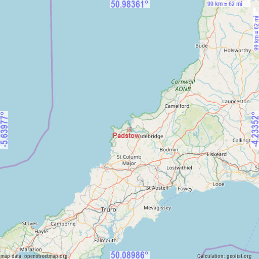
Padstow GPS coordinates[2]
50° 32' 19.86" North, 4° 56' 11.904" West
| Map corner | latitude | longitude |
|---|---|---|
| Upper-left | 50.98361°, | -5.63977° |
| Center: | 50.53885°, | -4.93664° |
| Lower-right: | 50.08986°, | -4.23352° |
| Map W x H: | 99.4×99.4 km | = 61.8×61.8mi |
| max Lat: | 60.39635° ⇑97.8% North |
| Padstow: | 50.53885° |
| min Lat: | ⇓2.2% South 34.60088° |
| min Long | Padstow | max Long |
| -7.64133° | -4.93664° | 32.95536° |
| W 4.1%⇐ | ⇒95.9% E |
Elevation
Elevation of Padstow is 12 m = 39 ft, and this is 60.9 m = 200 ft below average elevation for this country.
| Max E: |
515 m = 1690 ft | 89.9% |
| Avg. | 72.9 m = 239 ft | |
| Padstow | 12 m = 39 ft | |
Min E: |
-30 m = -98 ft | 10.1% |
See also: United Kingdom elevation on elevation.city.
Geographical zone
Padstow is located in North temperate zone (between Tropic of Cancer and the Arctic Circle). Distance of this North polar circle is 1781.8 km =1107.2 mi to North.| Distance of | km | miles | from Padstow |
|---|---|---|---|
| North Pole | 4387.7 | 2726.4 | to North |
| Arctic Circle | 1781.8 | 1107.2 | to North |
| Tropic Cancer | 3013.5 | 1872.5 | to South |
| Equator | 5619.4 | 3491.7 | to South |


Nearby cities:
15 places around Padstow: (largest is in red/bold)
• Bodmin
16.8 km =10.4 mi,  116°
116°
• Bugle
18.9 km =11.7 mi,  147°
147°
• Crantock
19.6 km =12.2 mi,  219°
219°
• Delabole
17.2 km =10.7 mi,  56°
56°
• Helland
16.1 km =10 mi,  105°
105°
• Lanivet
16.1 km =10 mi,  131°
131°
• Nanpean
19.5 km =12.1 mi,  165°
165°
• Newquay
16.8 km =10.4 mi, 215°
• Polzeath
3.7 km =2.3 mi,  21°
21°
• Roche
16.3 km =10.1 mi, 153°
• Rock
2.6 km =1.6 mi, 61°
• Saint Columb Major
11.9 km =7.4 mi,  182°
182°
• Saint Dennis
17.7 km =11 mi, 167°
• Tintagel
19.1 km =11.9 mi,  43°
43°
• Wadebridge
7.5 km =4.7 mi, 108°
Sources, notices
• [Note1] Compared only with cities in United Kingdom existing in our database
• [Src1] Map data: © OpenStreetMap contributors (CC-BY-SA)
• [Src2] Other city data from geonames.org with taken over terms of usage.
• [Src3] Geographical zone / Annual Mean Temperature by Robert A. Rohde @ Wikipedia
