Newport-on-Tay geodata
Newport-on-Tay (Scotland) is a populated place; located in United Kingdom in Europe/London (GMT+1) time zone. With population of 4,203 people, there are 1797 cities with bigger population in this country. Compared to other cities in United Kingdom, 96.5% of cities are located further ↓South; 73.9% of cities are located further →East and 62.4% of cities have higher elevation than Newport-on-Tay. Note1


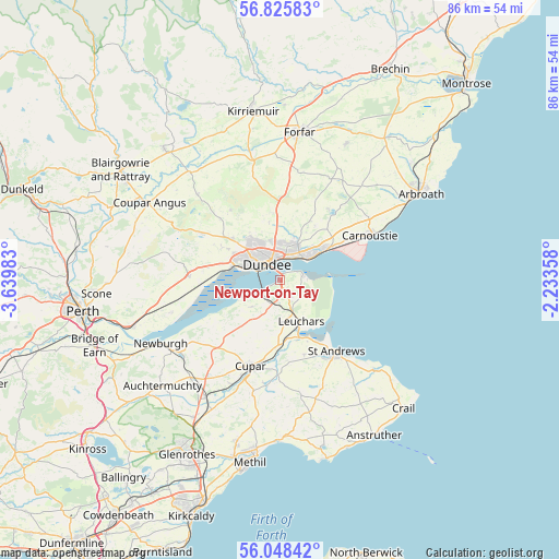
Newport-on-Tay GPS coordinates[2]
56° 26' 20.796" North, 2° 56' 12.12" West
| Map corner | latitude | longitude |
|---|---|---|
| Upper-left | 56.82583°, | -3.63983° |
| Center: | 56.43911°, | -2.9367° |
| Lower-right: | 56.04842°, | -2.23358° |
| Map W x H: | 86.4×86.4 km | = 53.7×53.7mi |
| max Lat: | 60.39635° ⇑3.5% North |
| Newport-on-Tay: | 56.43911° |
| min Lat: | ⇓96.5% South 34.60088° |
| min Long | Newport-on-Tay | max Long |
| -7.64133° | -2.9367° | 32.95536° |
| W 26.1%⇐ | ⇒73.9% E |
Elevation
Elevation of Newport-on-Tay is 43 m = 141 ft, and this is 29.9 m = 98 ft below average elevation for this country.
| Max E: |
515 m = 1690 ft | 62.4% |
| Avg. | 72.9 m = 239 ft | |
| Newport-on-Tay | 43 m = 141 ft | |
Min E: |
-30 m = -98 ft | 37.6% |
See also: United Kingdom elevation on elevation.city.
Geographical zone
Newport-on-Tay is located in North temperate zone (between Tropic of Cancer and the Arctic Circle). Distance of this North polar circle is 1125.7 km =699.5 mi to North.| Distance of | km | miles | from Newport-on-Tay |
|---|---|---|---|
| North Pole | 3731.6 | 2318.7 | to North |
| Arctic Circle | 1125.7 | 699.5 | to North |
| Tropic Cancer | 3669.5 | 2280.1 | to South |
| Equator | 6275.4 | 3899.4 | to South |


Nearby cities:
15 places around Newport-on-Tay: (largest is in red/bold)
• Balmullo
6.9 km =4.3 mi,  176°
176°
• Cupar
14.2 km =8.8 mi,  199°
199°
• Dundee
4.1 km =2.5 mi,  324°
324°
• Gauldry
5.9 km =3.7 mi,  229°
229°
• Guardbridge
8.7 km =5.4 mi,  159°
159°
• Invergowrie
8.1 km =5 mi,  287°
287°
• Leuchars
7.2 km =4.5 mi,  152°
152°
• Liff
10.5 km =6.5 mi,  299°
299°
• Longforgan
11.1 km =6.9 mi,  280°
280°
• Monifieth
8.8 km =5.5 mi,  56°
56°
• Muirhead
10.5 km =6.5 mi,  310°
310°
• Saint Andrews
14 km =8.7 mi,  142°
142°
• Strathkinness
12.2 km =7.6 mi, 162°
• Tayport
3.6 km =2.2 mi,  75°
75°
• Wellbank
10.6 km =6.6 mi,  26°
26°
Sources, notices
• [Note1] Compared only with cities in United Kingdom existing in our database
• [Src1] Map data: © OpenStreetMap contributors (CC-BY-SA)
• [Src2] Other city data from geonames.org with taken over terms of usage.
• [Src3] Geographical zone / Annual Mean Temperature by Robert A. Rohde @ Wikipedia
