Dundee geodata
Dundee (Scotland) is a seat of a second-order administrative division; located in United Kingdom in Europe/London (GMT+1) time zone. With population of 147,710 people, there are 63 cities with bigger population in this country. Compared to other cities in United Kingdom, 96.6% of cities are located further ↓South; 74.8% of cities are located further →East and 60.3% of cities have lower elevation than Dundee. Note1


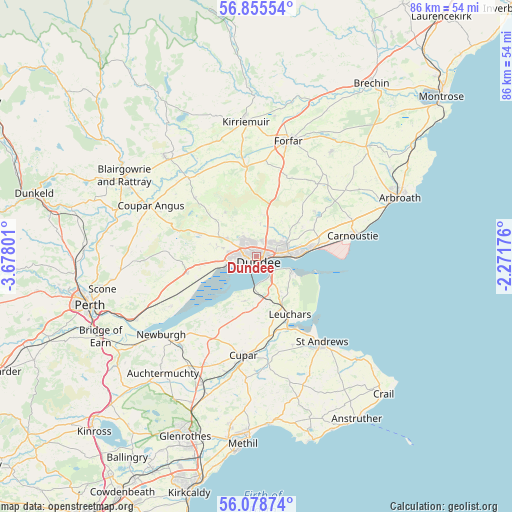
Dundee GPS coordinates[2]
56° 28' 8.868" North, 2° 58' 29.604" West
| Map corner | latitude | longitude |
|---|---|---|
| Upper-left | 56.85554°, | -3.67801° |
| Center: | 56.46913°, | -2.97489° |
| Lower-right: | 56.07874°, | -2.27176° |
| Map W x H: | 86.4×86.4 km | = 53.7×53.7mi |
| max Lat: | 60.39635° ⇑3.4% North |
| Dundee: | 56.46913° |
| min Lat: | ⇓96.6% South 34.60088° |
| min Long | Dundee | max Long |
| -7.64133° | -2.97489° | 32.95536° |
| W 25.2%⇐ | ⇒74.8% E |
Elevation
Elevation of Dundee is 77 m = 253 ft, and this is 4.1 m = 13 ft above average elevation for this country.
| Max E: |
515 m = 1690 ft | 39.7% |
| Dundee | 77 m 253 ft | |
| Avg. | 72.9 m = 239 ft | |
Min E: |
-30 m = -98 ft | 60.3% |
See also: Dundee elevation on elevation.city.
Geographical zone
Dundee is located in North temperate zone (between Tropic of Cancer and the Arctic Circle). Distance of this North polar circle is 1122.4 km =697.4 mi to North.| Distance of | km | miles | from Dundee |
|---|---|---|---|
| North Pole | 3728.3 | 2316.7 | to North |
| Arctic Circle | 1122.4 | 697.4 | to North |
| Tropic Cancer | 3672.9 | 2282.2 | to South |
| Equator | 6278.8 | 3901.5 | to South |


Nearby cities:
15 places around Dundee: (largest is in red/bold)
• Balmullo
10.6 km =6.6 mi,  164°
164°
• Gauldry
7.5 km =4.7 mi,  197°
197°
• Guardbridge
12.7 km =7.9 mi, 155°
• Inchture
12.2 km =7.6 mi,  257°
257°
• Invergowrie
5.4 km =3.4 mi, 260°
• Leuchars
11.3 km =7 mi,  149°
149°
• Liff
7 km =4.3 mi,  285°
285°
• Longforgan
8.7 km =5.4 mi, 261°
• Monifieth
9.8 km =6.1 mi,  81°
81°
• Muirhead
6.6 km =4.1 mi,  301°
301°
• Newport-on-Tay
4.1 km =2.5 mi,  144°
144°
• Newtyle
14.5 km =9 mi,  313°
313°
• Strathkinness
16.1 km =10 mi, 157°
• Tayport
6.3 km =3.9 mi,  112°
112°
• Wellbank
9.3 km =5.8 mi,  48°
48°
Sources, notices
• [Note1] Compared only with cities in United Kingdom existing in our database
• [Src1] Map data: © OpenStreetMap contributors (CC-BY-SA)
• [Src2] Other city data from geonames.org with taken over terms of usage.
• [Src3] Geographical zone / Annual Mean Temperature by Robert A. Rohde @ Wikipedia
