Muirhead geodata
Muirhead (Scotland) is a populated place; located in United Kingdom in Europe/London (GMT+1) time zone. With population of 1,542 people, there are 3000 cities with bigger population in this country. Compared to other cities in United Kingdom, 96.7% of cities are located further ↓South; 76.6% of cities are located further →East and 82.5% of cities have lower elevation than Muirhead. Note1


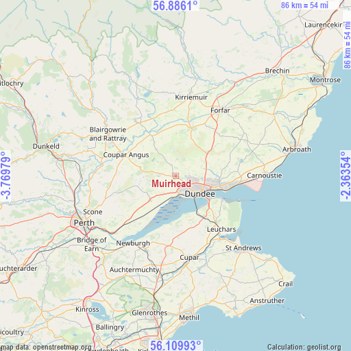
Muirhead GPS coordinates[2]
56° 30' 0" North, 3° 4' 0.012" West
| Map corner | latitude | longitude |
|---|---|---|
| Upper-left | 56.8861°, | -3.76979° |
| Center: | 56.5°, | -3.06667° |
| Lower-right: | 56.10993°, | -2.36354° |
| Map W x H: | 86.3×86.3 km | = 53.6×53.6mi |
| max Lat: | 60.39635° ⇑3.3% North |
| Muirhead: | 56.5° |
| min Lat: | ⇓96.7% South 34.60088° |
| min Long | Muirhead | max Long |
| -7.64133° | -3.06667° | 32.95536° |
| W 23.4%⇐ | ⇒76.6% E |
Elevation
Elevation of Muirhead is 125 m = 410 ft, and this is 52.1 m = 171 ft above average elevation for this country.
| Max E: |
515 m = 1690 ft | 17.5% |
| Muirhead | 125 m 410 ft | |
| Avg. | 72.9 m = 239 ft | |
Min E: |
-30 m = -98 ft | 82.5% |
See also: United Kingdom elevation on elevation.city.
Geographical zone
Muirhead is located in North temperate zone (between Tropic of Cancer and the Arctic Circle). Distance of this North polar circle is 1119 km =695.3 mi to North.| Distance of | km | miles | from Muirhead |
|---|---|---|---|
| North Pole | 3724.9 | 2314.5 | to North |
| Arctic Circle | 1119 | 695.3 | to North |
| Tropic Cancer | 3676.3 | 2284.3 | to South |
| Equator | 6282.2 | 3903.6 | to South |


Nearby cities:
15 places around Muirhead: (largest is in red/bold)
• Balmullo
16.1 km =10 mi,  148°
148°
• Burrelton
14.6 km =9.1 mi,  279°
279°
• Coupar Angus
13.3 km =8.3 mi,  292°
292°
• Dundee
6.6 km =4.1 mi,  121°
121°
• Errol
15 km =9.3 mi,  216°
216°
• Gauldry
11.1 km =6.9 mi,  161°
161°
• Inchture
8.8 km =5.5 mi,  226°
226°
• Invergowrie
4.3 km =2.7 mi,  175°
175°
• Liff
2 km =1.2 mi, 215°
• Longforgan
5.6 km =3.5 mi,  211°
211°
• Monifieth
15.4 km =9.6 mi,  97°
97°
• Newport-on-Tay
10.5 km =6.5 mi,  130°
130°
• Newtyle
8.1 km =5 mi,  323°
323°
• Tayport
12.9 km =8 mi, 117°
• Wellbank
13 km =8.1 mi,  78°
78°
Sources, notices
• [Note1] Compared only with cities in United Kingdom existing in our database
• [Src1] Map data: © OpenStreetMap contributors (CC-BY-SA)
• [Src2] Other city data from geonames.org with taken over terms of usage.
• [Src3] Geographical zone / Annual Mean Temperature by Robert A. Rohde @ Wikipedia
