Rochdale geodata
Rochdale (England) is a seat of a second-order administrative division; located in United Kingdom in Europe/London (GMT+1) time zone. With population of 97,550 people, there are 99 cities with bigger population in this country. Compared to other cities in United Kingdom, 72.4% of cities are located further ↓South; 58% of cities are located further →East and 83.1% of cities have lower elevation than Rochdale. Note1


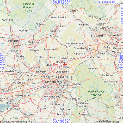
Rochdale GPS coordinates[2]
53° 37' 3.576" North, 2° 9' 18.72" West
| Map corner | latitude | longitude |
|---|---|---|
| Upper-left | 54.03268°, | -2.85833° |
| Center: | 53.61766°, | -2.1552° |
| Lower-right: | 53.19852°, | -1.45208° |
| Map W x H: | 92.7×92.7 km | = 57.6×57.6mi |
| max Lat: | 60.39635° ⇑27.6% North |
| Rochdale: | 53.61766° |
| min Lat: | ⇓72.4% South 34.60088° |
| min Long | Rochdale | max Long |
| -7.64133° | -2.1552° | 32.95536° |
| W 42%⇐ | ⇒58% E |
Elevation
Elevation of Rochdale is 127 m = 417 ft, and this is 54.1 m = 177 ft above average elevation for this country.
| Max E: |
515 m = 1690 ft | 16.9% |
| Rochdale | 127 m 417 ft | |
| Avg. | 72.9 m = 239 ft | |
Min E: |
-30 m = -98 ft | 83.1% |
See also: Rochdale elevation on elevation.city.
Geographical zone
Rochdale is located in North temperate zone (between Tropic of Cancer and the Arctic Circle). Distance of this North polar circle is 1439.4 km =894.4 mi to North.| Distance of | km | miles | from Rochdale |
|---|---|---|---|
| North Pole | 4045.3 | 2513.6 | to North |
| Arctic Circle | 1439.4 | 894.4 | to North |
| Tropic Cancer | 3355.8 | 2085.2 | to South |
| Equator | 5961.7 | 3704.4 | to South |


Nearby cities:
15 places around Rochdale: (largest is in red/bold)
• Bacup
10 km =6.2 mi,  342°
342°
• Bury
9.8 km =6.1 mi,  258°
258°
• Delph
10.8 km =6.7 mi,  121°
121°
• Heywood
5.1 km =3.2 mi,  236°
236°
• Littleborough
4.9 km =3 mi,  53°
53°
• Middleton
8.1 km =5 mi,  201°
201°
• Milnrow
2.9 km =1.8 mi,  104°
104°
• Oldham
8.9 km =5.5 mi,  164°
164°
• Rossendale
10.9 km =6.8 mi,  312°
312°
• Royton
6.2 km =3.9 mi, 159°
• Shaw
7.4 km =4.6 mi,  140°
140°
• Simister
10.1 km =6.3 mi,  220°
220°
• Walsden
9.2 km =5.7 mi,  23°
23°
• Wardle
3.9 km =2.4 mi, 21°
• Whitworth
4.5 km =2.8 mi, 341°
Sources, notices
• [Note1] Compared only with cities in United Kingdom existing in our database
• [Src1] Map data: © OpenStreetMap contributors (CC-BY-SA)
• [Src2] Other city data from geonames.org with taken over terms of usage.
• [Src3] Geographical zone / Annual Mean Temperature by Robert A. Rohde @ Wikipedia
