Lerwick geodata
Lerwick (Scotland) is a seat of a second-order administrative division; located in United Kingdom in Europe/London (GMT+1) time zone. With population of 7,040 people, there are 1325 cities with bigger population in this country. Compared to other cities in United Kingdom, 100% of cities are located further ↓South; 63.9% of cities are located further ←West and 85.8% of cities have higher elevation than Lerwick. Note1


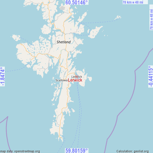
Lerwick GPS coordinates[2]
60° 9' 12.204" North, 1° 8' 39.372" West
| Map corner | latitude | longitude |
|---|---|---|
| Upper-left | 60.50146°, | -1.8474° |
| Center: | 60.15339°, | -1.14427° |
| Lower-right: | 59.80159°, | -0.44115° |
| Map W x H: | 77.8×77.8 km | = 48.3×48.3mi |
| max Lat: | 60.39635° ⇑0% North |
| Lerwick: | 60.15339° |
| min Lat: | ⇓100% South 34.60088° |
| min Long | Lerwick | max Long |
| -7.64133° | -1.14427° | 32.95536° |
| W 63.9%⇐ | ⇒36.1% E |
Elevation
Elevation of Lerwick is 15 m = 49 ft, and this is 57.9 m = 190 ft below average elevation for this country.
| Max E: |
515 m = 1690 ft | 85.8% |
| Avg. | 72.9 m = 239 ft | |
| Lerwick | 15 m = 49 ft | |
Min E: |
-30 m = -98 ft | 14.2% |
See also: United Kingdom elevation on elevation.city.
Geographical zone
Lerwick is located in North temperate zone (between Tropic of Cancer and the Arctic Circle). Distance of this North polar circle is 712.7 km =442.9 mi to North.| Distance of | km | miles | from Lerwick |
|---|---|---|---|
| North Pole | 3318.6 | 2062.1 | to North |
| Arctic Circle | 712.7 | 442.9 | to North |
| Tropic Cancer | 4082.5 | 2536.7 | to South |
| Equator | 6688.4 | 4156 | to South |


Nearby cities:
15 places around Lerwick: (largest is in red/bold)
• Brae
29.4 km =18.3 mi,  336°
336°
• Castletown
215 km =133.6 mi,  216°
216°
• Fraserburgh
278.7 km =173.2 mi,  190°
190°
• Halkirk
225.8 km =140.3 mi, 216°
• Helmsdale
267.8 km =166.4 mi,  212°
212°
• Kirkwall
165.3 km =102.7 mi, 218°
• Orkney
165.3 km =102.7 mi, 218°
• Rosehearty
278.7 km =173.2 mi, 191°
• Sandhaven
278.1 km =172.8 mi, 190°
• Sandwick
18 km =11.2 mi,  198°
198°
• Scalloway
7.5 km =4.7 mi,  257°
257°
• Stromness
179.3 km =111.4 mi, 222°
• Symbister
22 km =13.7 mi,  17°
17°
• Thurso
219.8 km =136.6 mi, 217°
• Wick
220.4 km =137 mi, 210°
Sources, notices
• [Note1] Compared only with cities in United Kingdom existing in our database
• [Src1] Map data: © OpenStreetMap contributors (CC-BY-SA)
• [Src2] Other city data from geonames.org with taken over terms of usage.
• [Src3] Geographical zone / Annual Mean Temperature by Robert A. Rohde @ Wikipedia
