Kirkwall geodata
Kirkwall (Scotland) is a seat of a second-order administrative division; located in United Kingdom in Europe/London (GMT+1) time zone. With population of 7,150 people, there are 1315 cities with bigger population in this country. Compared to other cities in United Kingdom, 99.9% of cities are located further ↓South; 74.4% of cities are located further →East and 99.5% of cities have higher elevation than Kirkwall. Note1


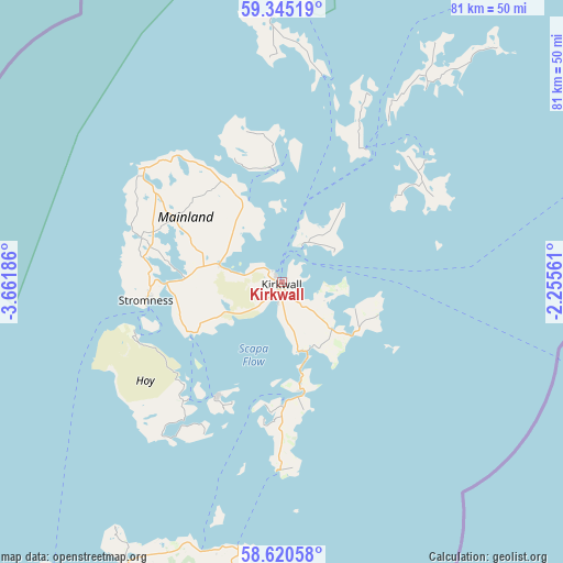
Kirkwall GPS coordinates[2]
58° 59' 5.244" North, 2° 57' 31.428" West
| Map corner | latitude | longitude |
|---|---|---|
| Upper-left | 59.34519°, | -3.66186° |
| Center: | 58.98479°, | -2.95873° |
| Lower-right: | 58.62058°, | -2.25561° |
| Map W x H: | 80.6×80.6 km | = 50.1×50.1mi |
| max Lat: | 60.39635° ⇑0.1% North |
| Kirkwall: | 58.98479° |
| min Lat: | ⇓99.9% South 34.60088° |
| min Long | Kirkwall | max Long |
| -7.64133° | -2.95873° | 32.95536° |
| W 25.6%⇐ | ⇒74.4% E |
Elevation
Elevation of Kirkwall is 3 m = 10 ft, and this is 69.9 m = 229 ft below average elevation for this country.
| Max E: |
515 m = 1690 ft | 99.5% |
| Avg. | 72.9 m = 239 ft | |
| Kirkwall | 3 m = 10 ft | |
Min E: |
-30 m = -98 ft | 0.5% |
See also: United Kingdom elevation on elevation.city.
Geographical zone
Kirkwall is located in North temperate zone (between Tropic of Cancer and the Arctic Circle). Distance of this North polar circle is 842.7 km =523.6 mi to North.| Distance of | km | miles | from Kirkwall |
|---|---|---|---|
| North Pole | 3448.6 | 2142.9 | to North |
| Arctic Circle | 842.7 | 523.6 | to North |
| Tropic Cancer | 3952.6 | 2456 | to South |
| Equator | 6558.5 | 4075.3 | to South |


Nearby cities:
15 places around Kirkwall: (largest is in red/bold)
• Brora
120.2 km =74.7 mi,  205°
205°
• Castletown
50.1 km =31.1 mi, 209°
• Cullen
144.2 km =89.6 mi,  176°
176°
• Dornoch
137.7 km =85.6 mi, 206°
• Findochty
143.2 km =89 mi, 178°
• Golspie
127.2 km =79 mi, 207°
• Halkirk
60.9 km =37.8 mi, 210°
• Helmsdale
104.6 km =65 mi,  202°
202°
• Hopeman
144.7 km =89.9 mi,  190°
190°
• Lossiemouth
141.8 km =88.1 mi, 187°
• Orkney
0 km =0 mi,  251°
251°
• Portknockie
142.7 km =88.7 mi, 177°
• Stromness
19.5 km =12.1 mi,  263°
263°
• Thurso
54.5 km =33.9 mi,  216°
216°
• Wick
61.2 km =38 mi, 187°
Sources, notices
• [Note1] Compared only with cities in United Kingdom existing in our database
• [Src1] Map data: © OpenStreetMap contributors (CC-BY-SA)
• [Src2] Other city data from geonames.org with taken over terms of usage.
• [Src3] Geographical zone / Annual Mean Temperature by Robert A. Rohde @ Wikipedia
