Kirkby geodata
Kirkby (England) is a populated place; located in United Kingdom in Europe/London (GMT+1) time zone. With population of 42,744 people, there are 280 cities with bigger population in this country. Compared to other cities in United Kingdom, 69.4% of cities are located further ↓South; 73% of cities are located further →East and 76.3% of cities have higher elevation than Kirkby. Note1


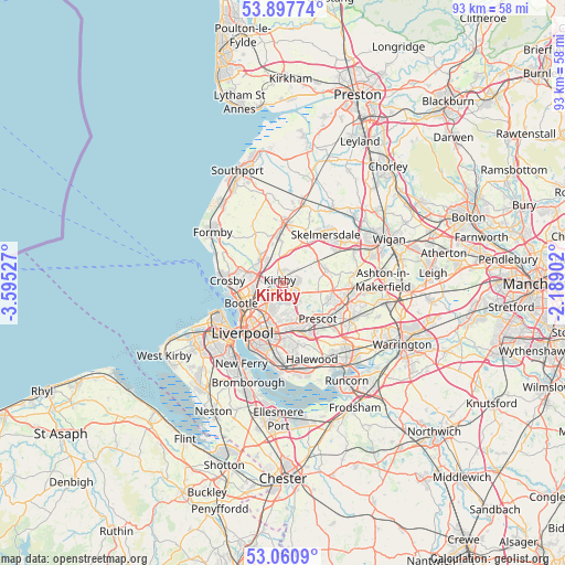
Kirkby GPS coordinates[2]
53° 28' 52.968" North, 2° 53' 31.74" West
| Map corner | latitude | longitude |
|---|---|---|
| Upper-left | 53.89774°, | -3.59527° |
| Center: | 53.48138°, | -2.89215° |
| Lower-right: | 53.0609°, | -2.18902° |
| Map W x H: | 93×93 km | = 57.8×57.8mi |
| max Lat: | 60.39635° ⇑30.6% North |
| Kirkby: | 53.48138° |
| min Lat: | ⇓69.4% South 34.60088° |
| min Long | Kirkby | max Long |
| -7.64133° | -2.89215° | 32.95536° |
| W 27%⇐ | ⇒73% E |
Elevation
Elevation of Kirkby is 25 m = 82 ft, and this is 47.9 m = 157 ft below average elevation for this country.
| Max E: |
515 m = 1690 ft | 76.3% |
| Avg. | 72.9 m = 239 ft | |
| Kirkby | 25 m = 82 ft | |
Min E: |
-30 m = -98 ft | 23.7% |
See also: Kirkby elevation on elevation.city.
Geographical zone
Kirkby is located in North temperate zone (between Tropic of Cancer and the Arctic Circle). Distance of this North polar circle is 1454.6 km =903.8 mi to North.| Distance of | km | miles | from Kirkby |
|---|---|---|---|
| North Pole | 4060.5 | 2523.1 | to North |
| Arctic Circle | 1454.6 | 903.8 | to North |
| Tropic Cancer | 3340.7 | 2075.8 | to South |
| Equator | 5946.6 | 3695 | to South |


Nearby cities:
15 places around Kirkby: (largest is in red/bold)
• Bootle
8.4 km =5.2 mi,  258°
258°
• Clubmoor
6 km =3.7 mi,  207°
207°
• Crosby
9.4 km =5.8 mi,  267°
267°
• Eccleston
8 km =5 mi,  115°
115°
• Huyton
8.5 km =5.3 mi,  155°
155°
• Knowsley
4 km =2.5 mi,  140°
140°
• Litherland
7.1 km =4.4 mi, 259°
• Maghull
5 km =3.1 mi,  320°
320°
• Melling
1.6 km =1 mi,  277°
277°
• Ormskirk
9.5 km =5.9 mi,  4°
4°
• Prescot
8.4 km =5.2 mi,  133°
133°
• Rainford
7.2 km =4.5 mi,  71°
71°
• Thornton
7.4 km =4.6 mi,  286°
286°
• Waterloo
9.2 km =5.7 mi, 265°
• Westhead
9.6 km =6 mi,  19°
19°
Sources, notices
• [Note1] Compared only with cities in United Kingdom existing in our database
• [Src1] Map data: © OpenStreetMap contributors (CC-BY-SA)
• [Src2] Other city data from geonames.org with taken over terms of usage.
• [Src3] Geographical zone / Annual Mean Temperature by Robert A. Rohde @ Wikipedia
