Kidderminster geodata
Kidderminster (England) is a populated place; located in United Kingdom in Europe/London (GMT+1) time zone. With population of 57,059 people, there are 199 cities with bigger population in this country. Compared to other cities in United Kingdom, 51.9% of cities are located further ↑North; 60.3% of cities are located further →East and 66.8% of cities have higher elevation than Kidderminster. Note1


Kidderminster GPS coordinates[2]
52° 23' 17.484" North, 2° 15' 0" West
| Map corner | latitude | longitude |
|---|---|---|
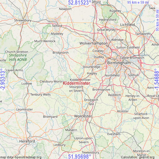
| Upper-left | 52.81523°, | -2.95313° |
| Center: | 52.38819°, | -2.25° |
| Lower-right: | 51.95698°, | -1.54688° |
| Map W x H: | 95.4×95.4 km | = 59.3×59.3mi |
| max Lat: | 60.39635° ⇑51.9% North |
| Kidderminster: | 52.38819° |
| min Lat: | ⇓48.1% South 34.60088° |
| min Long | Kidderminster | max Long |
| -7.64133° | -2.25° | 32.95536° |
| W 39.7%⇐ | ⇒60.3% E |
Elevation
Elevation of Kidderminster is 37 m = 121 ft, and this is 35.9 m = 118 ft below average elevation for this country.
| Max E: |
515 m = 1690 ft | 66.8% |
| Avg. | 72.9 m = 239 ft | |
| Kidderminster | 37 m = 121 ft | |
Min E: |
-30 m = -98 ft | 33.2% |
See also: Kidderminster elevation on elevation.city.
Geographical zone
Kidderminster is located in North temperate zone (between Tropic of Cancer and the Arctic Circle). Distance of this North polar circle is 1576.2 km =979.4 mi to North.| Distance of | km | miles | from Kidderminster |
|---|---|---|---|
| North Pole | 4182 | 2598.6 | to North |
| Arctic Circle | 1576.2 | 979.4 | to North |
| Tropic Cancer | 3219.1 | 2000.3 | to South |
| Equator | 5825 | 3619.5 | to South |


Nearby cities:
15 places around Kidderminster: (largest is in red/bold)
• Alveley
10.4 km =6.5 mi,  317°
317°
• Belbroughton
8.9 km =5.5 mi,  87°
87°
• Bewdley
4.8 km =3 mi,  253°
253°
• Callow Hill
9 km =5.6 mi, 248°
• Far Forest
10.4 km =6.5 mi,  259°
259°
• Hagley
9.3 km =5.8 mi,  62°
62°
• Hampton
12.6 km =7.8 mi,  313°
313°
• Hartlebury
6.2 km =3.9 mi,  169°
169°
• Highley
11.2 km =7 mi, 306°
• Kinvere
7 km =4.3 mi,  9°
9°
• Ombersley
13.1 km =8.1 mi, 173°
• Romsley
8.2 km =5.1 mi,  326°
326°
• Stone
4.2 km =2.6 mi,  125°
125°
• Stourbridge
10.5 km =6.5 mi,  43°
43°
• Stourport-on-Severn
5.8 km =3.6 mi,  200°
200°
Sources, notices
• [Note1] Compared only with cities in United Kingdom existing in our database
• [Src1] Map data: © OpenStreetMap contributors (CC-BY-SA)
• [Src2] Other city data from geonames.org with taken over terms of usage.
• [Src3] Geographical zone / Annual Mean Temperature by Robert A. Rohde @ Wikipedia
