Greenhead geodata
Greenhead (England) is a seat of a third-order administrative division; located in United Kingdom in Europe/London (GMT+0) time zone. In our database, there are 4977 cities with bigger population. Compared to other cities in United Kingdom, 86.3% of cities are located further ↓South; 65.5% of cities are located further →East and 94.6% of cities have lower elevation than Greenhead. Note1


Greenhead GPS coordinates[2]
54° 58' 0.012" North, 2° 31' 0.012" West
| Map corner | latitude | longitude |
|---|---|---|
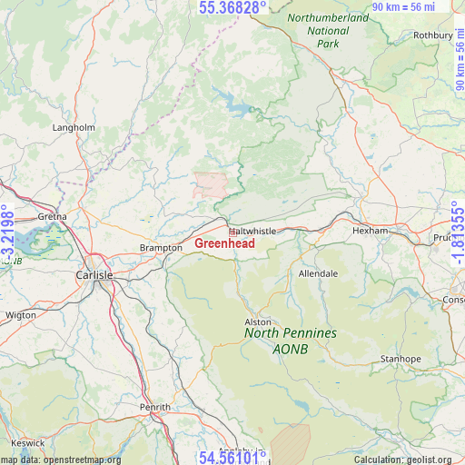
| Upper-left | 55.36828°, | -3.2198° |
| Center: | 54.96667°, | -2.51667° |
| Lower-right: | 54.56101°, | -1.81355° |
| Map W x H: | 89.8×89.8 km | = 55.8×55.8mi |
| max Lat: | 60.39635° ⇑13.7% North |
| Greenhead: | 54.96667° |
| min Lat: | ⇓86.3% South 34.60088° |
| min Long | Greenhead | max Long |
| -7.64133° | -2.51667° | 32.95536° |
| W 34.5%⇐ | ⇒65.5% E |
Elevation
Elevation of Greenhead is 180 m = 591 ft, and this is 107.1 m = 351 ft above average elevation for this country.
| Max E: |
515 m = 1690 ft | 5.4% |
| Greenhead | 180 m 591 ft | |
| Avg. | 72.9 m = 239 ft | |
Min E: |
-30 m = -98 ft | 94.6% |
See also: United Kingdom elevation on elevation.city.
Geographical zone
Greenhead is located in North temperate zone (between Tropic of Cancer and the Arctic Circle). Distance of this North polar circle is 1289.5 km =801.3 mi to North.| Distance of | km | miles | from Greenhead |
|---|---|---|---|
| North Pole | 3895.3 | 2420.4 | to North |
| Arctic Circle | 1289.5 | 801.3 | to North |
| Tropic Cancer | 3505.8 | 2178.4 | to South |
| Equator | 6111.7 | 3797.6 | to South |


Nearby cities:
15 places around Greenhead: (largest is in red/bold)
• Acomb
26 km =16.2 mi,  83°
83°
• Allendale Town
18.3 km =11.4 mi,  114°
114°
• Alston
18.2 km =11.3 mi,  164°
164°
• Bardon Mill
11.1 km =6.9 mi, 84°
• Bellingham
25.9 km =16.1 mi,  40°
40°
• Birtley
24.9 km =15.5 mi,  58°
58°
• Brampton
14 km =8.7 mi,  262°
262°
• Haltwhistle
3.9 km =2.4 mi, 82°
• Haydon Bridge
17.2 km =10.7 mi,  86°
86°
• Hexham
26.3 km =16.3 mi, 89°
• Humshaugh
26 km =16.2 mi,  72°
72°
• Scotby
24.4 km =15.2 mi,  249°
249°
• Wall
24.7 km =15.3 mi, 81°
• Warden
24.5 km =15.2 mi, 85°
• Wetheral
22.2 km =13.8 mi, 245°
Sources, notices
• [Note1] Compared only with cities in United Kingdom existing in our database
• [Src1] Map data: © OpenStreetMap contributors (CC-BY-SA)
• [Src2] Other city data from geonames.org with taken over terms of usage.
• [Src3] Geographical zone / Annual Mean Temperature by Robert A. Rohde @ Wikipedia
