Alston geodata
Alston (England) is a populated place; located in United Kingdom in Europe/London (GMT+0) time zone. With population of 1,105 people, there are 3482 cities with bigger population in this country. Compared to other cities in United Kingdom, 85.1% of cities are located further ↓South; 63.8% of cities are located further →East and 99.6% of cities have lower elevation than Alston. Note1
Administrative division(s):
- Level 1: England
- Level 2: Cumbria
- Level 3: Eden District
- Level 4: Alston Moor


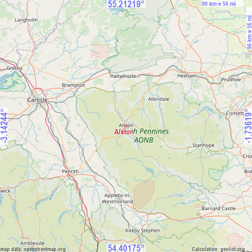
Alston GPS coordinates[2]
54° 48' 32.4" North, 2° 26' 21.516" West
| Map corner | latitude | longitude |
|---|---|---|
| Upper-left | 55.21219°, | -3.14244° |
| Center: | 54.809°, | -2.43931° |
| Lower-right: | 54.40175°, | -1.73619° |
| Map W x H: | 90.1×90.1 km | = 56×56mi |
| max Lat: | 60.39635° ⇑14.9% North |
| Alston: | 54.809° |
| min Lat: | ⇓85.1% South 34.60088° |
| min Long | Alston | max Long |
| -7.64133° | -2.43931° | 32.95536° |
| W 36.2%⇐ | ⇒63.8% E |
Elevation
Elevation of Alston is 298 m = 978 ft, and this is 225.1 m = 739 ft above average elevation for this country.
| Max E: |
515 m = 1690 ft | 0.40000000000001% |
| Alston | 298 m 978 ft | |
| Avg. | 72.9 m = 239 ft | |
Min E: |
-30 m = -98 ft | 99.6% |
See also: United Kingdom elevation on elevation.city.
Geographical zone
Alston is located in North temperate zone (between Tropic of Cancer and the Arctic Circle). Distance of this North polar circle is 1307 km =812.1 mi to North.| Distance of | km | miles | from Alston |
|---|---|---|---|
| North Pole | 3912.9 | 2431.4 | to North |
| Arctic Circle | 1307 | 812.1 | to North |
| Tropic Cancer | 3488.3 | 2167.5 | to South |
| Equator | 6094.2 | 3786.8 | to South |


Nearby cities:
15 places around Alston: (largest is in red/bold)
• Allendale Town
15.3 km =9.5 mi,  49°
49°
• Appleby-in-Westmorland
26 km =16.2 mi,  187°
187°
• Bardon Mill
19.5 km =12.1 mi,  18°
18°
• Brampton
24.5 km =15.2 mi,  309°
309°
• Greenhead
18.2 km =11.3 mi,  344°
344°
• Haltwhistle
18 km =11.2 mi,  356°
356°
• Haydon Bridge
22.2 km =13.8 mi,  33°
33°
• Holwick
27 km =16.8 mi,  135°
135°
• Kirkby Thore
21.9 km =13.6 mi,  201°
201°
• Langwathby
19.3 km =12 mi,  229°
229°
• Lazonby
18.3 km =11.4 mi,  248°
248°
• Newbiggin
27 km =16.8 mi,  133°
133°
• Penrith
25.9 km =16.1 mi, 232°
• Temple Sowerby
22 km =13.7 mi,  208°
208°
• Wetheral
26.6 km =16.5 mi,  288°
288°
Sources, notices
• [Note1] Compared only with cities in United Kingdom existing in our database
• [Src1] Map data: © OpenStreetMap contributors (CC-BY-SA)
• [Src2] Other city data from geonames.org with taken over terms of usage.
• [Src3] Geographical zone / Annual Mean Temperature by Robert A. Rohde @ Wikipedia
