Grantown on Spey geodata
Grantown on Spey (Scotland) is a populated place; located in United Kingdom in Europe/London (GMT+1) time zone. With population of 2,440 people, there are 2372 cities with bigger population in this country. Compared to other cities in United Kingdom, 98.1% of cities are located further ↓South; 83.8% of cities are located further →East and 98% of cities have lower elevation than Grantown on Spey. Note1


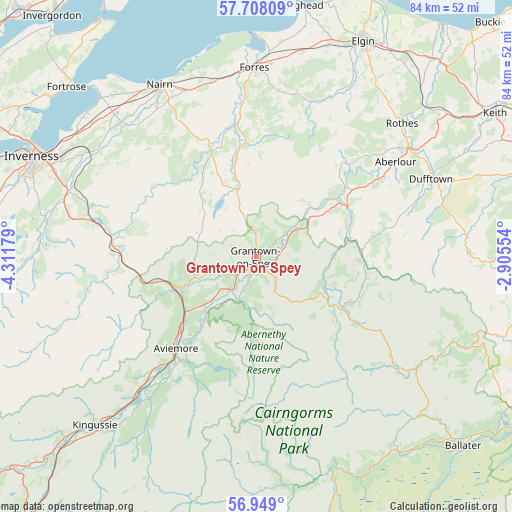
Grantown on Spey GPS coordinates[2]
57° 19' 49.836" North, 3° 36' 31.212" West
| Map corner | latitude | longitude |
|---|---|---|
| Upper-left | 57.70809°, | -4.31179° |
| Center: | 57.33051°, | -3.60867° |
| Lower-right: | 56.949°, | -2.90554° |
| Map W x H: | 84.4×84.4 km | = 52.4×52.4mi |
| max Lat: | 60.39635° ⇑1.9% North |
| Grantown on Spey: | 57.33051° |
| min Lat: | ⇓98.1% South 34.60088° |
| min Long | Grantown on Spe | max Long |
| -7.64133° | -3.60867° | 32.95536° |
| W 16.2%⇐ | ⇒83.8% E |
Elevation
Elevation of Grantown on Spey is 223 m = 732 ft, and this is 150.1 m = 492 ft above average elevation for this country.
| Max E: |
515 m = 1690 ft | 2% |
| Grantown on Spey | 223 m 732 ft | |
| Avg. | 72.9 m = 239 ft | |
Min E: |
-30 m = -98 ft | 98% |
See also: United Kingdom elevation on elevation.city.
Geographical zone
Grantown on Spey is located in North temperate zone (between Tropic of Cancer and the Arctic Circle). Distance of this North polar circle is 1026.6 km =637.9 mi to North.| Distance of | km | miles | from Grantown on Spey |
|---|---|---|---|
| North Pole | 3632.5 | 2257.1 | to North |
| Arctic Circle | 1026.6 | 637.9 | to North |
| Tropic Cancer | 3768.6 | 2341.7 | to South |
| Equator | 6374.6 | 3961 | to South |


Nearby cities:
15 places around Grantown on Spey: (largest is in red/bold)
• Auldearn
29.6 km =18.4 mi,  336°
336°
• Aviemore
19.9 km =12.4 mi,  221°
221°
• Balloch
35.3 km =21.9 mi,  300°
300°
• Boat of Garten
12.6 km =7.8 mi, 224°
• Charlestown of Aberlour
27.8 km =17.3 mi,  55°
55°
• Croy
32.8 km =20.4 mi,  309°
309°
• Culloden
36.3 km =22.6 mi, 298°
• Dufftown
31.6 km =19.6 mi,  66°
66°
• Findhorn
36.3 km =22.6 mi,  0°
0°
• Forres
31.1 km =19.3 mi,  358°
358°
• Kinloss
33.9 km =21.1 mi, 3°
• Nairn
32.2 km =20 mi,  329°
329°
• Nethy Bridge
7.8 km =4.8 mi,  201°
201°
• Rothes
32.4 km =20.1 mi,  47°
47°
• Westhill
36 km =22.4 mi, 296°
Sources, notices
• [Note1] Compared only with cities in United Kingdom existing in our database
• [Src1] Map data: © OpenStreetMap contributors (CC-BY-SA)
• [Src2] Other city data from geonames.org with taken over terms of usage.
• [Src3] Geographical zone / Annual Mean Temperature by Robert A. Rohde @ Wikipedia
