Nethy Bridge geodata
Nethy Bridge (Scotland) is a populated place; located in United Kingdom in Europe/London (GMT+1) time zone. With population of 660 people, there are 4375 cities with bigger population in this country. Compared to other cities in United Kingdom, 98% of cities are located further ↓South; 84.3% of cities are located further →East and 97.5% of cities have lower elevation than Nethy Bridge. Note1


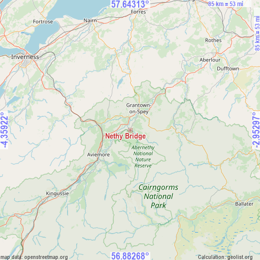
Nethy Bridge GPS coordinates[2]
57° 15' 53.532" North, 3° 39' 21.924" West
| Map corner | latitude | longitude |
|---|---|---|
| Upper-left | 57.64313°, | -4.35922° |
| Center: | 57.26487°, | -3.65609° |
| Lower-right: | 56.88268°, | -2.95297° |
| Map W x H: | 84.6×84.6 km | = 52.6×52.6mi |
| max Lat: | 60.39635° ⇑2% North |
| Nethy Bridge: | 57.26487° |
| min Lat: | ⇓98% South 34.60088° |
| min Long | Nethy Bridge | max Long |
| -7.64133° | -3.65609° | 32.95536° |
| W 15.7%⇐ | ⇒84.3% E |
Elevation
Elevation of Nethy Bridge is 215 m = 705 ft, and this is 142.1 m = 466 ft above average elevation for this country.
| Max E: |
515 m = 1690 ft | 2.5% |
| Nethy Bridge | 215 m 705 ft | |
| Avg. | 72.9 m = 239 ft | |
Min E: |
-30 m = -98 ft | 97.5% |
See also: United Kingdom elevation on elevation.city.
Geographical zone
Nethy Bridge is located in North temperate zone (between Tropic of Cancer and the Arctic Circle). Distance of this North polar circle is 1033.9 km =642.4 mi to North.| Distance of | km | miles | from Nethy Bridge |
|---|---|---|---|
| North Pole | 3639.8 | 2261.7 | to North |
| Arctic Circle | 1033.9 | 642.4 | to North |
| Tropic Cancer | 3761.3 | 2337.2 | to South |
| Equator | 6367.3 | 3956.5 | to South |


Nearby cities:
15 places around Nethy Bridge: (largest is in red/bold)
• Auldearn
35.6 km =22.1 mi,  345°
345°
• Aviemore
12.8 km =8 mi,  232°
232°
• Balloch
37.4 km =23.2 mi,  312°
312°
• Boat of Garten
6.2 km =3.9 mi,  254°
254°
• Charlestown of Aberlour
34.5 km =21.4 mi,  48°
48°
• Croy
36 km =22.4 mi,  321°
321°
• Culloden
38.2 km =23.7 mi, 310°
• Dufftown
37.6 km =23.4 mi,  57°
57°
• Grantown on Spey
7.8 km =4.8 mi,  21°
21°
• Kingussie
31.5 km =19.6 mi, 229°
• Milton of Leys
37.4 km =23.2 mi,  303°
303°
• Nairn
37.6 km =23.4 mi,  339°
339°
• Newtonmore
35.7 km =22.2 mi, 231°
• Smithton
38.1 km =23.7 mi, 308°
• Westhill
37.5 km =23.3 mi, 308°
Sources, notices
• [Note1] Compared only with cities in United Kingdom existing in our database
• [Src1] Map data: © OpenStreetMap contributors (CC-BY-SA)
• [Src2] Other city data from geonames.org with taken over terms of usage.
• [Src3] Geographical zone / Annual Mean Temperature by Robert A. Rohde @ Wikipedia
