Craigavon geodata
Craigavon (Northern Ireland) is a seat of a second-order administrative division; located in United Kingdom in Europe/London (GMT+1) time zone. With population of 59,236 people, there are 190 cities with bigger population in this country. Compared to other cities in United Kingdom, 81.5% of cities are located further ↓South; 99.1% of cities are located further →East and 69.2% of cities have higher elevation than Craigavon. Note1


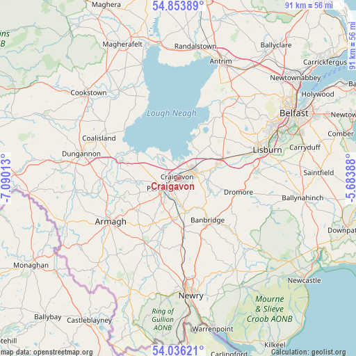
Craigavon GPS coordinates[2]
54° 26' 49.524" North, 6° 23' 13.2" West
| Map corner | latitude | longitude |
|---|---|---|
| Upper-left | 54.85389°, | -7.09013° |
| Center: | 54.44709°, | -6.387° |
| Lower-right: | 54.03621°, | -5.68388° |
| Map W x H: | 90.9×90.9 km | = 56.5×56.5mi |
| max Lat: | 60.39635° ⇑18.5% North |
| Craigavon: | 54.44709° |
| min Lat: | ⇓81.5% South 34.60088° |
| min Long | Craigavon | max Long |
| -7.64133° | -6.387° | 32.95536° |
| W 0.9%⇐ | ⇒99.1% E |
Elevation
Elevation of Craigavon is 34 m = 112 ft, and this is 38.9 m = 128 ft below average elevation for this country.
| Max E: |
515 m = 1690 ft | 69.2% |
| Avg. | 72.9 m = 239 ft | |
| Craigavon | 34 m = 112 ft | |
Min E: |
-30 m = -98 ft | 30.8% |
See also: Craigavon elevation on elevation.city.
Geographical zone
Craigavon is located in North temperate zone (between Tropic of Cancer and the Arctic Circle). Distance of this North polar circle is 1347.2 km =837.1 mi to North.| Distance of | km | miles | from Craigavon |
|---|---|---|---|
| North Pole | 3953.1 | 2456.3 | to North |
| Arctic Circle | 1347.2 | 837.1 | to North |
| Tropic Cancer | 3448 | 2142.5 | to South |
| Equator | 6053.9 | 3761.7 | to South |


Nearby cities:
15 places around Craigavon: (largest is in red/bold)
• Annahilt
25.1 km =15.6 mi,  93°
93°
• Armagh
21.1 km =13.1 mi,  239°
239°
• Banbridge
12.7 km =7.9 mi,  148°
148°
• Coalisland
22.9 km =14.2 mi,  297°
297°
• Crumlin
22.3 km =13.9 mi,  30°
30°
• Gilford
8.5 km =5.3 mi,  168°
168°
• Glenavy
19.6 km =12.2 mi, 34°
• Hillsborough
20.1 km =12.5 mi,  84°
84°
• Lisburn
24.3 km =15.1 mi,  69°
69°
• Magheralin
8.5 km =5.3 mi, 74°
• Moira
10.9 km =6.8 mi, 70°
• Moy
18.1 km =11.2 mi,  271°
271°
• Portadown
4.6 km =2.9 mi,  234°
234°
• Tandragee
10.4 km =6.5 mi,  189°
189°
• Waringstown
5.8 km =3.6 mi,  104°
104°
Sources, notices
• [Note1] Compared only with cities in United Kingdom existing in our database
• [Src1] Map data: © OpenStreetMap contributors (CC-BY-SA)
• [Src2] Other city data from geonames.org with taken over terms of usage.
• [Src3] Geographical zone / Annual Mean Temperature by Robert A. Rohde @ Wikipedia
