Ogmore-by-Sea geodata
Ogmore-by-Sea (Wales) is a populated place; located in United Kingdom in Europe/London (GMT+1) time zone. With population of 878 people, there are 3859 cities with bigger population in this country. Compared to other cities in United Kingdom, 79% of cities are located further ↑North; 84% of cities are located further →East and 51.8% of cities have lower elevation than Ogmore-by-Sea. Note1


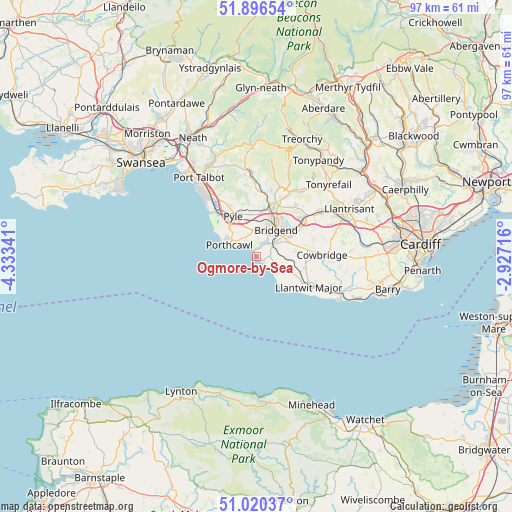
Ogmore-by-Sea GPS coordinates[2]
51° 27' 38.016" North, 3° 37' 49.008" West
| Map corner | latitude | longitude |
|---|---|---|
| Upper-left | 51.89654°, | -4.33341° |
| Center: | 51.46056°, | -3.63028° |
| Lower-right: | 51.02037°, | -2.92716° |
| Map W x H: | 97.4×97.4 km | = 60.5×60.5mi |
| max Lat: | 60.39635° ⇑79% North |
| Ogmore-by-Sea: | 51.46056° |
| min Lat: | ⇓21% South 34.60088° |
| min Long | Ogmore-by-Sea | max Long |
| -7.64133° | -3.63028° | 32.95536° |
| W 16%⇐ | ⇒84% E |
Elevation
Elevation of Ogmore-by-Sea is 63 m = 207 ft, and this is 9.9 m = 32 ft below average elevation for this country.
| Max E: |
515 m = 1690 ft | 48.2% |
| Avg. | 72.9 m = 239 ft | |
| Ogmore-by-Sea | 63 m = 207 ft | |
Min E: |
-30 m = -98 ft | 51.8% |
See also: United Kingdom elevation on elevation.city.
Geographical zone
Ogmore-by-Sea is located in North temperate zone (between Tropic of Cancer and the Arctic Circle). Distance of this North polar circle is 1679.3 km =1043.5 mi to North.| Distance of | km | miles | from Ogmore-by-Sea |
|---|---|---|---|
| North Pole | 4285.2 | 2662.7 | to North |
| Arctic Circle | 1679.3 | 1043.5 | to North |
| Tropic Cancer | 3116 | 1936.2 | to South |
| Equator | 5721.9 | 3555.4 | to South |


Nearby cities:
15 places around Ogmore-by-Sea: (largest is in red/bold)
• Aberkenfig
9.2 km =5.7 mi,  15°
15°
• Betws
12.4 km =7.7 mi,  13°
13°
• Bridgend
6.2 km =3.9 mi,  36°
36°
• Cefn Cribwr
8.1 km =5 mi,  348°
348°
• Coity
8.6 km =5.3 mi, 37°
• Ewenny
4.6 km =2.9 mi,  58°
58°
• Heol-y-Cyw
12.2 km =7.6 mi, 37°
• Llangan
9.5 km =5.9 mi,  71°
71°
• Llantwit Major
11.4 km =7.1 mi,  119°
119°
• Merthyr Mawr
3.2 km =2 mi,  27°
27°
• Pencoed
11.4 km =7.1 mi,  52°
52°
• Penllyn
10.6 km =6.6 mi,  81°
81°
• Porthcawl
5.5 km =3.4 mi,  292°
292°
• Pyle
7.9 km =4.9 mi,  322°
322°
• Wick
6.1 km =3.8 mi,  112°
112°
Sources, notices
• [Note1] Compared only with cities in United Kingdom existing in our database
• [Src1] Map data: © OpenStreetMap contributors (CC-BY-SA)
• [Src2] Other city data from geonames.org with taken over terms of usage.
• [Src3] Geographical zone / Annual Mean Temperature by Robert A. Rohde @ Wikipedia
