Gateshead geodata
Gateshead (England) is a seat of a second-order administrative division; located in United Kingdom in Europe/London (GMT+1) time zone. With population of 77,649 people, there are 130 cities with bigger population in this country. Compared to other cities in United Kingdom, 86.3% of cities are located further ↓South; 53.1% of cities are located further ←West and 55.1% of cities have higher elevation than Gateshead. Note1


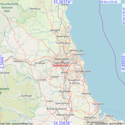
Gateshead GPS coordinates[2]
54° 57' 43.524" North, 1° 36' 6.048" West
| Map corner | latitude | longitude |
|---|---|---|
| Upper-left | 55.36374°, | -2.3048° |
| Center: | 54.96209°, | -1.60168° |
| Lower-right: | 54.55638°, | -0.89855° |
| Map W x H: | 89.8×89.8 km | = 55.8×55.8mi |
| max Lat: | 60.39635° ⇑13.7% North |
| Gateshead: | 54.96209° |
| min Lat: | ⇓86.3% South 34.60088° |
| min Long | Gateshead | max Long |
| -7.64133° | -1.60168° | 32.95536° |
| W 53.1%⇐ | ⇒46.9% E |
Elevation
Elevation of Gateshead is 53 m = 174 ft, and this is 19.9 m = 65 ft below average elevation for this country.
| Max E: |
515 m = 1690 ft | 55.1% |
| Avg. | 72.9 m = 239 ft | |
| Gateshead | 53 m = 174 ft | |
Min E: |
-30 m = -98 ft | 44.9% |
See also: Gateshead elevation on elevation.city.
Geographical zone
Gateshead is located in North temperate zone (between Tropic of Cancer and the Arctic Circle). Distance of this North polar circle is 1290 km =801.6 mi to North.| Distance of | km | miles | from Gateshead |
|---|---|---|---|
| North Pole | 3895.9 | 2420.8 | to North |
| Arctic Circle | 1290 | 801.6 | to North |
| Tropic Cancer | 3505.3 | 2178.1 | to South |
| Equator | 6111.2 | 3797.3 | to South |


Nearby cities:
15 places around Gateshead: (largest is in red/bold)
• Benwell
4.5 km =2.8 mi,  285°
285°
• Blaydon-on-Tyne
7.2 km =4.5 mi,  272°
272°
• Felling
2.2 km =1.4 mi,  117°
117°
• Gosforth
4.3 km =2.7 mi,  347°
347°
• Hazlerigg
9.1 km =5.7 mi,  344°
344°
• Hebburn
5.6 km =3.5 mi,  77°
77°
• Jarrow
7.8 km =4.8 mi,  74°
74°
• Lamesley
5.2 km =3.2 mi,  185°
185°
• Newburn
9.5 km =5.9 mi, 287°
• Newcastle upon Tyne
1.5 km =0.9 mi,  327°
327°
• The Boldons
9.7 km =6 mi,  102°
102°
• Wallsend
5.4 km =3.4 mi,  53°
53°
• Washington
8.8 km =5.5 mi,  141°
141°
• Whickham
5.1 km =3.2 mi,  248°
248°
• Wideopen
9.3 km =5.8 mi, 351°
Sources, notices
• [Note1] Compared only with cities in United Kingdom existing in our database
• [Src1] Map data: © OpenStreetMap contributors (CC-BY-SA)
• [Src2] Other city data from geonames.org with taken over terms of usage.
• [Src3] Geographical zone / Annual Mean Temperature by Robert A. Rohde @ Wikipedia
