Bamburgh geodata
Bamburgh (England) is a seat of a third-order administrative division; located in United Kingdom in Europe/London (GMT+0) time zone. With population of 279 people, there are 4958 cities with bigger population in this country. Compared to other cities in United Kingdom, 89.3% of cities are located further ↓South; 50.5% of cities are located further ←West and 75.4% of cities have higher elevation than Bamburgh. Note1


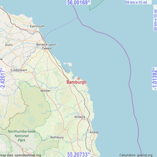
Bamburgh GPS coordinates[2]
55° 36' 23.472" North, 1° 43' 1.344" West
| Map corner | latitude | longitude |
|---|---|---|
| Upper-left | 56.00169°, | -2.42017° |
| Center: | 55.60652°, | -1.71704° |
| Lower-right: | 55.20733°, | -1.01392° |
| Map W x H: | 88.3×88.3 km | = 54.9×54.9mi |
| max Lat: | 60.39635° ⇑10.7% North |
| Bamburgh: | 55.60652° |
| min Lat: | ⇓89.3% South 34.60088° |
| min Long | Bamburgh | max Long |
| -7.64133° | -1.71704° | 32.95536° |
| W 50.5%⇐ | ⇒49.5% E |
Elevation
Elevation of Bamburgh is 26 m = 85 ft, and this is 46.9 m = 154 ft below average elevation for this country.
| Max E: |
515 m = 1690 ft | 75.4% |
| Avg. | 72.9 m = 239 ft | |
| Bamburgh | 26 m = 85 ft | |
Min E: |
-30 m = -98 ft | 24.6% |
See also: United Kingdom elevation on elevation.city.
Geographical zone
Bamburgh is located in North temperate zone (between Tropic of Cancer and the Arctic Circle). Distance of this North polar circle is 1218.3 km =757 mi to North.| Distance of | km | miles | from Bamburgh |
|---|---|---|---|
| North Pole | 3824.2 | 2376.2 | to North |
| Arctic Circle | 1218.3 | 757 | to North |
| Tropic Cancer | 3576.9 | 2222.6 | to South |
| Equator | 6182.9 | 3841.9 | to South |


Nearby cities:
15 places around Bamburgh: (largest is in red/bold)
• Alnmouth
24.1 km =15 mi,  162°
162°
• Alnwick
21.5 km =13.4 mi,  178°
178°
• Ancroft
20.6 km =12.8 mi,  300°
300°
• Beadnell
7.7 km =4.8 mi,  136°
136°
• Belford
7.3 km =4.5 mi,  264°
264°
• Doddington
18.2 km =11.3 mi, 262°
• Ellingham
9 km =5.6 mi,  187°
187°
• Embleton
13.3 km =8.3 mi, 157°
• Ford
23.2 km =14.4 mi,  277°
277°
• Lesbury
23.8 km =14.8 mi,  166°
166°
• Longhoughton
20.5 km =12.7 mi, 162°
• Lowick
17.1 km =10.6 mi,  286°
286°
• North Sunderland
4.7 km =2.9 mi,  134°
134°
• Seahouses
4.8 km =3 mi, 126°
• Wooler
19.7 km =12.2 mi,  250°
250°
Sources, notices
• [Note1] Compared only with cities in United Kingdom existing in our database
• [Src1] Map data: © OpenStreetMap contributors (CC-BY-SA)
• [Src2] Other city data from geonames.org with taken over terms of usage.
• [Src3] Geographical zone / Annual Mean Temperature by Robert A. Rohde @ Wikipedia
