Appleby-in-Westmorland geodata
Appleby-in-Westmorland (England) is a populated place; located in United Kingdom in Europe/London (GMT+1) time zone. With population of 3,048 people, there are 2108 cities with bigger population in this country. Compared to other cities in United Kingdom, 82.9% of cities are located further ↓South; 64.9% of cities are located further →East and 87.3% of cities have lower elevation than Appleby-in-Westmorland. Note1
Administrative division(s):
- Level 1: England
- Level 2: Cumbria
- Level 3: Eden District
- Level 4: Appleby-in-Westmorland


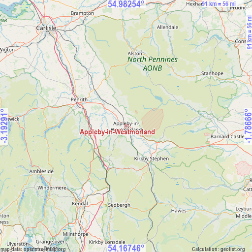
Appleby-in-Westmorland GPS coordinates[2]
54° 34' 37.344" North, 2° 29' 23.208" West
| Map corner | latitude | longitude |
|---|---|---|
| Upper-left | 54.98254°, | -3.19291° |
| Center: | 54.57704°, | -2.48978° |
| Lower-right: | 54.16746°, | -1.78666° |
| Map W x H: | 90.6×90.6 km | = 56.3×56.3mi |
| max Lat: | 60.39635° ⇑17.1% North |
| Appleby-in-Westmorland: | 54.57704° |
| min Lat: | ⇓82.9% South 34.60088° |
| min Long | Appleby-in-West | max Long |
| -7.64133° | -2.48978° | 32.95536° |
| W 35.1%⇐ | ⇒64.9% E |
Elevation
Elevation of Appleby-in-Westmorland is 140 m = 459 ft, and this is 67.1 m = 220 ft above average elevation for this country.
| Max E: |
515 m = 1690 ft | 12.7% |
| Appleby-in-Westmorland | 140 m 459 ft | |
| Avg. | 72.9 m = 239 ft | |
Min E: |
-30 m = -98 ft | 87.3% |
See also: United Kingdom elevation on elevation.city.
Geographical zone
Appleby-in-Westmorland is located in North temperate zone (between Tropic of Cancer and the Arctic Circle). Distance of this North polar circle is 1332.8 km =828.2 mi to North.| Distance of | km | miles | from Appleby-in-Westmorland |
|---|---|---|---|
| North Pole | 3938.7 | 2447.4 | to North |
| Arctic Circle | 1332.8 | 828.2 | to North |
| Tropic Cancer | 3462.5 | 2151.5 | to South |
| Equator | 6068.4 | 3770.7 | to South |


Nearby cities:
15 places around Appleby-in-Westmorland: (largest is in red/bold)
• Alston
26 km =16.2 mi,  7°
7°
• Greystoke
26.7 km =16.6 mi,  292°
292°
• Holwick
23.2 km =14.4 mi,  73°
73°
• Kirkby Stephen
14.8 km =9.2 mi,  141°
141°
• Kirkby Thore
7.1 km =4.4 mi,  319°
319°
• Langwathby
17.6 km =10.9 mi, 319°
• Lazonby
23.4 km =14.5 mi, 324°
• Mickleton
28.5 km =17.7 mi,  83°
83°
• Middleton in Teesdale
26.8 km =16.7 mi, 78°
• Newbiggin
23.9 km =14.9 mi, 72°
• Penrith
19.9 km =12.4 mi,  299°
299°
• Sedbergh
28.5 km =17.7 mi,  184°
184°
• Shap
13 km =8.1 mi,  247°
247°
• Stainton
21.4 km =13.3 mi, 290°
• Temple Sowerby
9.7 km =6 mi,  311°
311°
Sources, notices
• [Note1] Compared only with cities in United Kingdom existing in our database
• [Src1] Map data: © OpenStreetMap contributors (CC-BY-SA)
• [Src2] Other city data from geonames.org with taken over terms of usage.
• [Src3] Geographical zone / Annual Mean Temperature by Robert A. Rohde @ Wikipedia
