Huntly geodata
Huntly (Scotland) is a populated place; located in United Kingdom in Europe/London (GMT+1) time zone. With population of 4,720 people, there are 1690 cities with bigger population in this country. Compared to other cities in United Kingdom, 98.4% of cities are located further ↓South; 70.7% of cities are located further →East and 83.1% of cities have lower elevation than Huntly. Note1


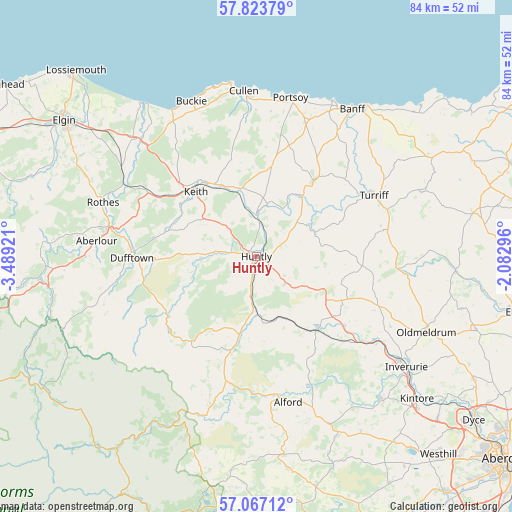
Huntly GPS coordinates[2]
57° 26' 50.676" North, 2° 47' 9.888" West
| Map corner | latitude | longitude |
|---|---|---|
| Upper-left | 57.82379°, | -3.48921° |
| Center: | 57.44741°, | -2.78608° |
| Lower-right: | 57.06712°, | -2.08296° |
| Map W x H: | 84.1×84.1 km | = 52.3×52.3mi |
| max Lat: | 60.39635° ⇑1.6% North |
| Huntly: | 57.44741° |
| min Lat: | ⇓98.4% South 34.60088° |
| min Long | Huntly | max Long |
| -7.64133° | -2.78608° | 32.95536° |
| W 29.3%⇐ | ⇒70.7% E |
Elevation
Elevation of Huntly is 127 m = 417 ft, and this is 54.1 m = 177 ft above average elevation for this country.
| Max E: |
515 m = 1690 ft | 16.9% |
| Huntly | 127 m 417 ft | |
| Avg. | 72.9 m = 239 ft | |
Min E: |
-30 m = -98 ft | 83.1% |
See also: United Kingdom elevation on elevation.city.
Geographical zone
Huntly is located in North temperate zone (between Tropic of Cancer and the Arctic Circle). Distance of this North polar circle is 1013.6 km =629.8 mi to North.| Distance of | km | miles | from Huntly |
|---|---|---|---|
| North Pole | 3619.5 | 2249.1 | to North |
| Arctic Circle | 1013.6 | 629.8 | to North |
| Tropic Cancer | 3781.6 | 2349.8 | to South |
| Equator | 6387.6 | 3969.1 | to South |


Nearby cities:
15 places around Huntly: (largest is in red/bold)
• Aberchirder
15.7 km =9.8 mi,  36°
36°
• Alford
24.4 km =15.2 mi,  168°
168°
• Bridgend
5.6 km =3.5 mi,  199°
199°
• Buckie
27.5 km =17.1 mi,  337°
337°
• Charlestown of Aberlour
26.4 km =16.4 mi,  275°
275°
• Cullen
27.1 km =16.8 mi,  355°
355°
• Dufftown
20.4 km =12.7 mi,  269°
269°
• Fochabers
26.4 km =16.4 mi,  314°
314°
• Insch
15.6 km =9.7 mi,  138°
138°
• Keith
13.8 km =8.6 mi,  315°
315°
• Portgordon
27.6 km =17.1 mi,  330°
330°
• Portsoy
26.7 km =16.6 mi,  12°
12°
• Rothes
26.6 km =16.5 mi,  289°
289°
• Rothienorman
19.7 km =12.2 mi,  101°
101°
• Turriff
22 km =13.7 mi,  62°
62°
Sources, notices
• [Note1] Compared only with cities in United Kingdom existing in our database
• [Src1] Map data: © OpenStreetMap contributors (CC-BY-SA)
• [Src2] Other city data from geonames.org with taken over terms of usage.
• [Src3] Geographical zone / Annual Mean Temperature by Robert A. Rohde @ Wikipedia
